
In Los Angeles, California, stands the Ohashi family house. Far from static, it is the result of carefully constructed conditions that, over time, have produced a multitude of physical forms, living arrangements, ownership models, and locations. The Ohashi house has been in Boyle Heights, Pomona, Heart Mountain, Denver, and Boyle Heights again. Though there are maps and legal documents that attempt to fix the Ohashi house in time and place, the site cannot be understood in the traditional geographical sense—as existing in one space, one setting. Though physical location is not to be taken for granted, site is a condition that is marked by temporal and material relationships. As the Ohashi family moved, the house became houses—unified across these disparate physical sites through the process of architectural aliasing. Aliasing—a term used across a range of fields from audio engineering to digital motion graphics, ENT surgery, and psychology—describes the layering of different signals at the same or different frequencies that results in an output that is unique while adding something new, or revealing something about the original signals without altering them. Often, there is a mismatch in frequencies that is interpreted as a perceptual distortion, an artifact. Architectural aliasing does not look to correct these artifacts but understands them as an output that becomes as present as the original signals. When this unpredictable multiplicity is considered, architecture as the built medium changes its relation to ownership. The social practices of property and ownership can change and have spatial implications. Existing in a state of simultaneous multiplicity, the Ohashi house is an example of this.
Within the context of an essay that renders the Ohashi house as the product of moving between geographic locations, simultaneous truths, and unique lived realities that are situated at the same location through the framework of architectural aliasing, the footnotes are another signal. For persons of Japanese ancestry who lived, or had relatives who lived, in the United States during the first half of the twentieth century, it is likely that parts of this essay are familiar. This is a history that lives in and through memories and stories. With this, and the simultaneity of architectural aliasing, the footnotes should be read concurrently with the text.1
Real Property
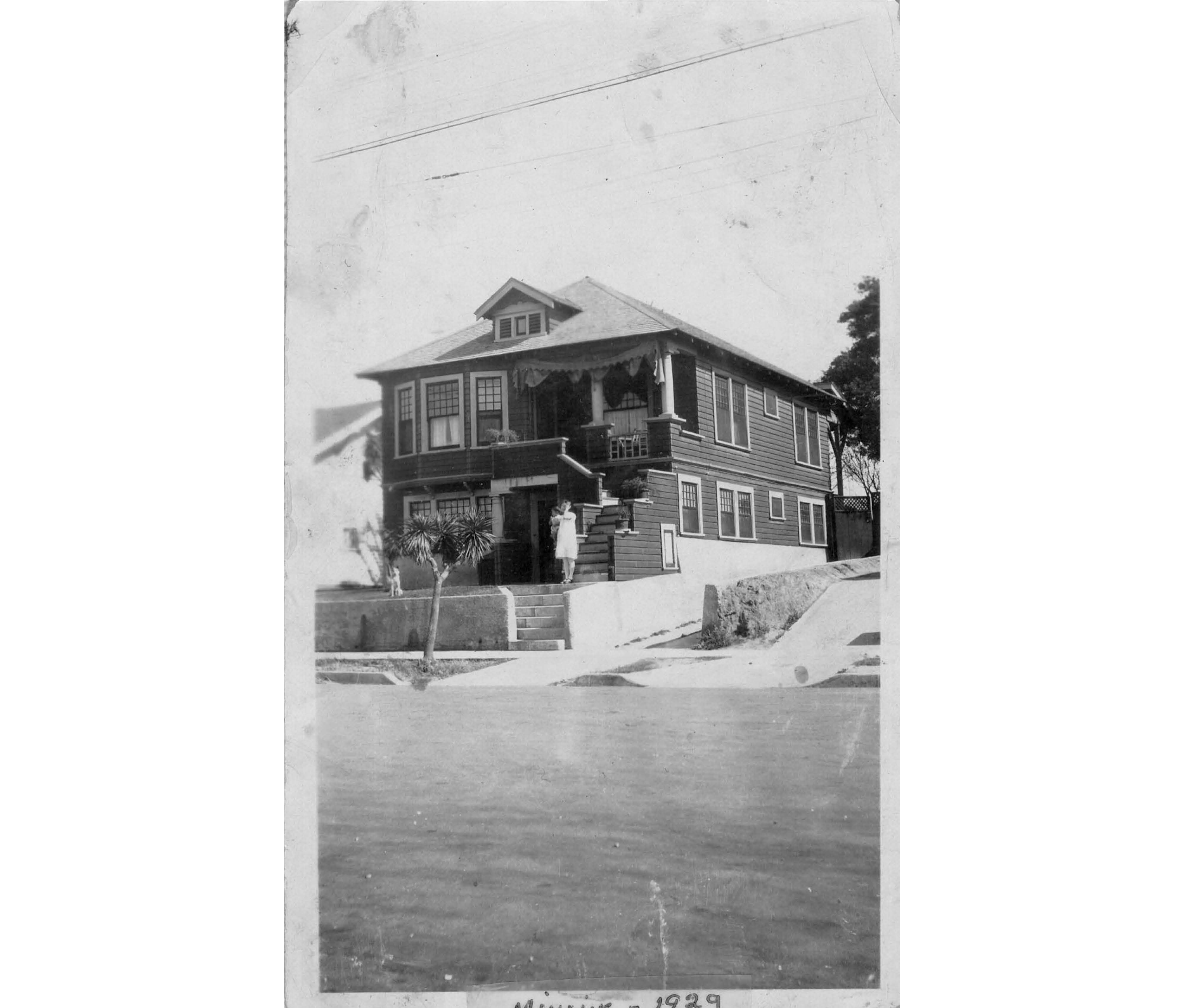
The house that would be the Boyle Heights house was built in 1906, but for Bachan and Mr. Ohashi, Japanese nationals, it was not real until 1914, the year their first child was born in California. They named her Minnie, and it was her citizenship status that brought the Ohashis and the house into a possible relation, that made the property at 3417 East 4th Street in Boyle Heights real: a real possibility, in the common sense, of real property, in the legal sense.2 Here, real is not a matter of existence but of relation—relation between resident and property, between resident and the state.3 The house on East 4th Street became real in 1914, and yet still existed prior.
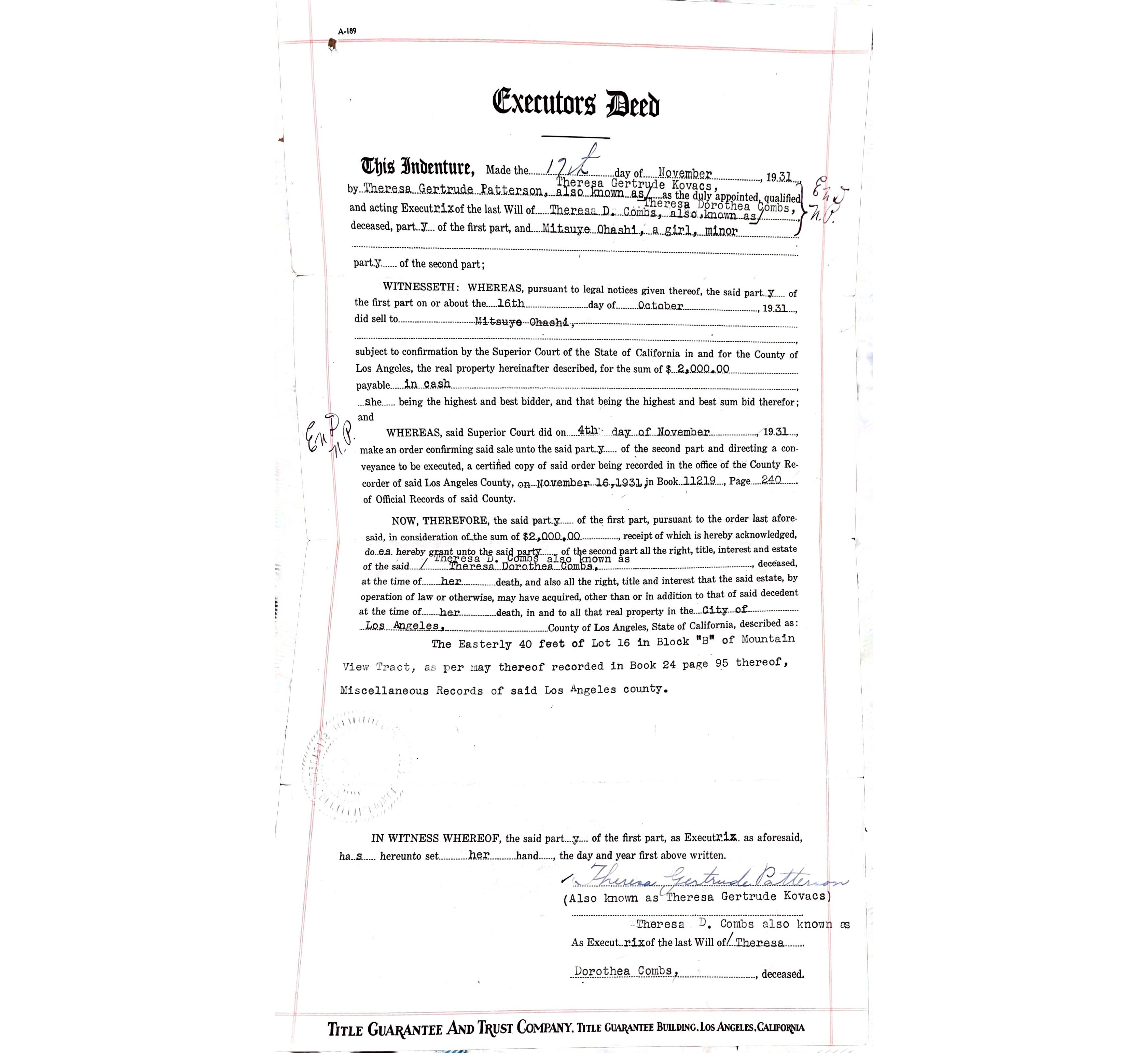
In 1931, with financial assistance from her father, Mr. Ohashi, twelve-year-old Minnie, a US citizen, bought the house on East 4th Street for her family.4 The Ohashis moved in shortly after the purchase. By this time, they were a family of seven: Bachan, Mr. Ohashi, Minnie, Frances, Ray, Joe, and Emy—eight counting Mr. Ohashi’s dog. The Boyle Heights house was a family house that was carefully tended to by Bachan. Though Mr. Ohashi and Bachan were still considered “ineligible aliens,” the law’s narrow understanding of ethnicity and identity left a gap. Like the Haradas5 before them, this gap was what was leveraged to allow Minnie to own property. The law could not capture Minnie. In conflating whiteness with American citizenship, it could not hold both her Americanness and her Japaneseness. Minnie’s ethnicity and nationality did not negate each other. Instead, she existed in a state of multiplicity that subverted the norms of citizenship. This wobbliness within the law allowed some to purchase property, but the consequence of the law itself was the further solidification of whiteness through exclusion.6 Whiteness became a form of de facto citizenship with undeniable social and fungible capital.
Based on a 1906 permit application filed with Public Works for a new build, the Boyle Heights house was built of lath, plaster, and wood siding. The permit issued by the Department of Building and Safety indicates that, by the time the Ohashis moved in, it was two stories, likely a combination of balloon and stick framing—sheet 1438 of the fourteenth volume of the Los Angeles Sanborn fire insurance maps issued in 1921 confirms this.7 The map also notes the roof of wood shingles of “mixed composition,” the placement of the bay windows on the second story, and the location of the shed and detached garage of similar construction that share the lot. The overall thickness of the wall section, measuring from interior to exterior, is approximately four inches. The Boyle Heights house was not the only structure that was documented this way.8
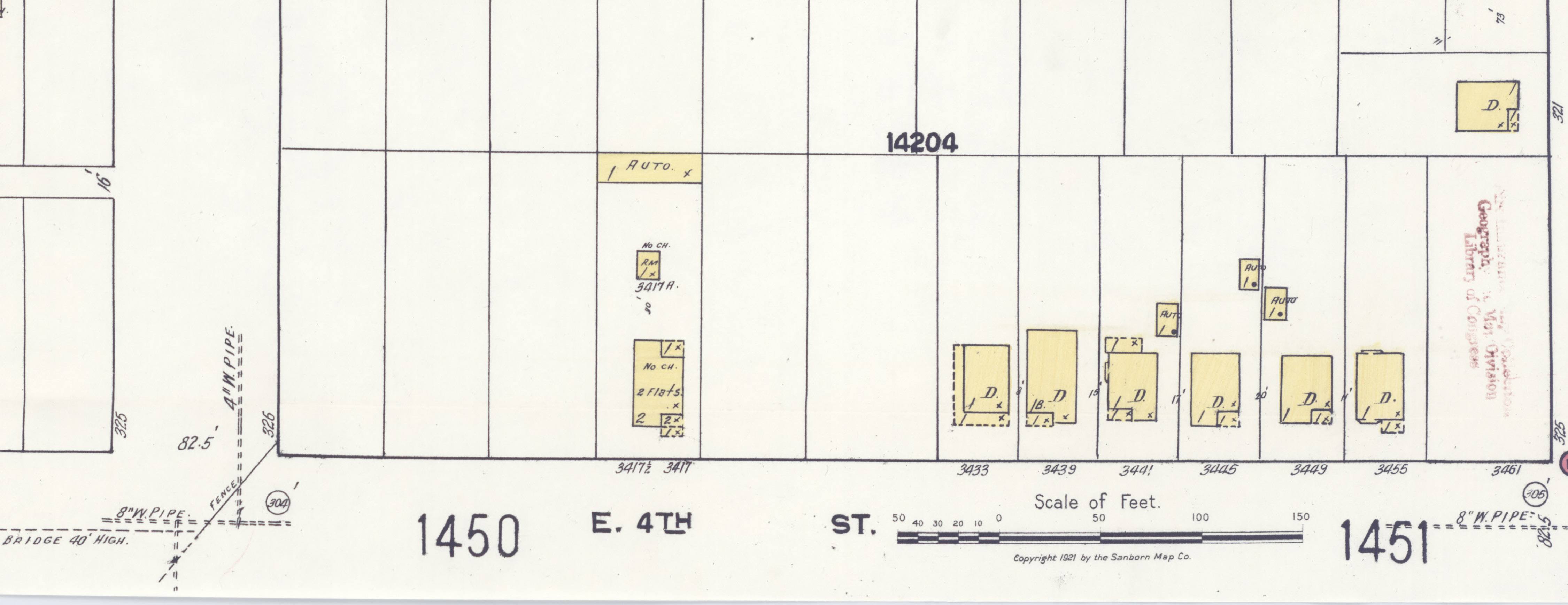
In these documents—deeds, permits, Sanborn maps—the house is not just broken down into its material parts. Rather, these documents understand the materials as the house. They speak to how the house is understood through the law, how it is constructed, what it is constructed with, where it is constructed, and whether it is commercial or residential. Though this combination of information alludes to it, the documents do not note how a building is being lived in. Instead of being documented as a single-family unit, the Boyle Heights house was listed as a two-unit dwelling. There was no code for an intergenerational family unit, so it was coded as an apartment. It is true that at one point, a sickly relative lived in one of the upstairs bedrooms, and that after they were married, Joe and his wife would continue to live in the Boyle Heights house, but they were a single family, just not single-family to the surveyors. Over the next decade, the house, with its plaster walls and wood shingles, would remain static. December 8, 1941, one day after the bombing of Pearl Harbor,9 would mark the ten-year anniversary of Minnie, a “girl minor,” as the deed states, going into escrow on the house.
Camp
In 1942,10 the Boyle Heights house on 4th Street multiplied. It became two. It had to. One, the house in a normative sense, the Boyle Heights house, stayed in Boyle Heights, while the other, the Ohashi household, was relocated to the Pomona Fairgrounds.11 New labels were imposed on the Ohashis with this forced removal. The Ohashi children, all of whom were born in the US, were no longer called “citizens” but “non-aliens.” While Bachan and Mr. Ohashi were still called “ineligible aliens,” they all earned the new title “alien enemies.” Their relationship to East 4th Street, to their own citizenship, property, stability, and security, was disrupted and contingent on wartime authority. These euphemistic labels12 came with government-sanctioned theft of real and personal property; they came with a loss of bodily autonomy and with the blatant degradation of civil rights.
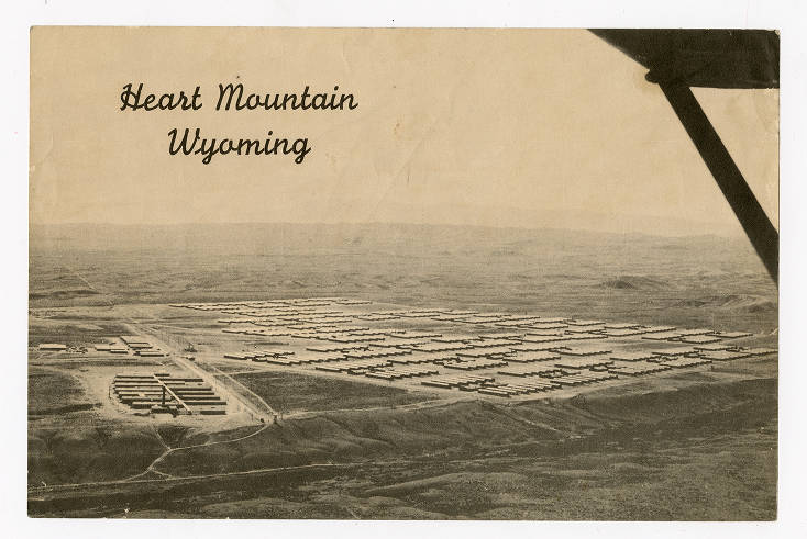
After three months, the house moved again and took a three-day train ride to Heart Mountain, Wyoming, also known as “Camp.”13 This doubling and movement happened to thousands of houses. Regardless of citizenship status, Japanese and Japanese Americans on the West Coast were forced to move to remote “alien environments.”14 Some went to Tule Lake and Manzanar in California, others to Minidoka, Idaho; Poston and Gila River, Arizona; Topaz, Utah; Granada, Colorado; and Rohwer and Jerome, Arkansas. These sites, these markedly unfamiliar environments, were strategic; they were part of the violence of internment. Each house—the house that stayed and the house that moved—was equally real, equally present. Where the Boyle Heights house became real through ownership prompted by Minnie’s birth and citizenship, here, the houses are real as a matter of existence and relationship. The houses remained linked through a simultaneity based not on form but on material and belonging.
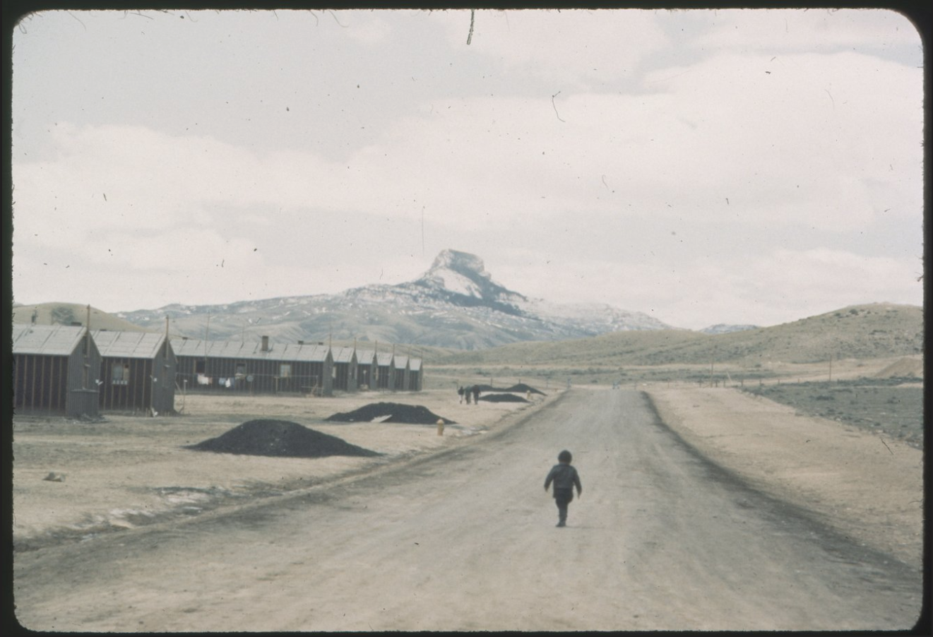
The gaps and knots in the wood of the shoddily constructed Camp house were patched using tightly rolled newspaper, parts of crates, and the lids from tin cans. These solutions only held up so well during Wyoming’s winters and frequent dust storms. Strong winds carried fine dust into the barracks, which seeped through the floorboards and window frames like rising steam.15 This alien environment, though far from alien to the Apsáalooke,16 was another scale to which belonging and identity were weaponized. This weaponization was multiplied from the individual with the use of the term alien to families, communities, and an entire ethnic group with the implementation of the Alien Land Laws and the Alien Enemies Act. Despite having to constantly confront such harsh conditions—ecological, social, and political—life was lived, and forms of belonging were constructed.
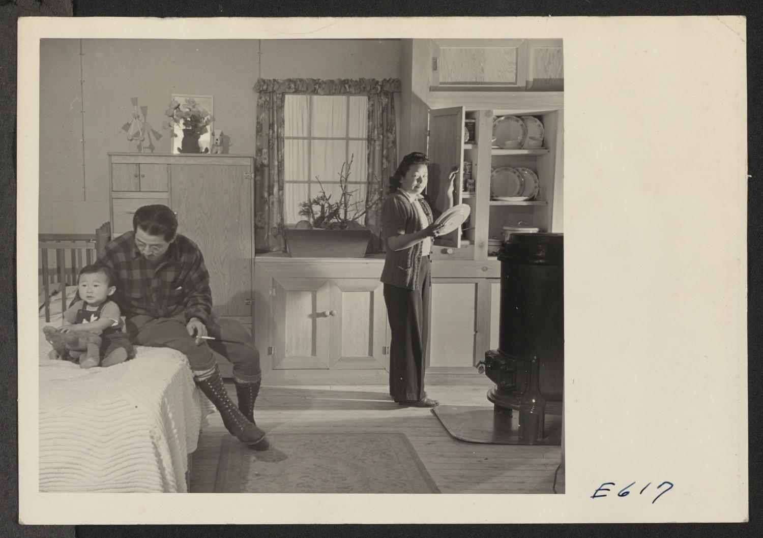
The thinness of the barracks walls meant families lived with little separation from the environment, from neighbors, and even from one another. Though every sound that traveled through the walls was a reminder of their forced removal and all they had left behind, residents began to work with the walls. Both out of necessity and as an act of quiet resilience, sheets were hung to create partitions, scraps from barracks construction were used to patch holes, and eventually, materials were ordered to construct their own walls within their “apartments.” Some families went a step further, creating a simulacrum of a house. Using the stick frame of the barrack as an armature, they attached moldings, shelves, and fixtures out of found and purchased materials to the 2x4s. Some images of barrack interiors have a distant, dreamlike quality. Seeing a kitchen set made from catalogue-ordered materials and likely intended for installation in a suburb somewhere instead of in an internment camp, is jarring. Those who had experience with millwork, woodworking, or construction set up makeshift shops to show and teach others what they could build. The walls the internees constructed, and the other architectural elements they added to them, are defiance in the form of persistent efforts to create familiarity and comfort in the face of imprisonment, demonization, and isolation. Images taken by photographers hired by the War Relocation Authority (WRA) show the conditions of camp, serving a documentary purpose while they themselves are artifacts of these acts of defiance and expressions of resilience. When looking at these images, for a brief second, one can almost forget that Heart Mountain was not a town but an internment camp,17 that the people in the photographs are “alien enemies,” and that the barracks were the property of the WRA. Little belonged to the residents but the walls they built.
Architectural Aliasing
Life, death, and everything in between continued while the Ohashis were in Camp. Mr. Ohashi died, and a funeral service, which was well attended, had to be organized. Emy was part of Heart Mountain High School’s first graduating class. They had printed programs and everything. She even got to wear a cap and gown.
About a year after entering Camp, the Ohashis, with the promise of jobs and other places to stay, were able to leave.18 They went to Denver, Colorado, where they worked on a farm, at a foundry, for the WRA,19 and at the University of Denver, where they would remain until the end of the war. Emy would take classes at the university so Bachan could receive Social Security benefits as a widow. In 1945, the Ohashis returned to 3417 East 4th Street. The houses returned too.20 Apart from a few missing serving dishes,21 everything was the same. The neighbor, who had watched the house while they were gone, must have had a party. The house was just as the Sanborn maps described: two stories, a wood frame with plaster, wood siding, and a mixed-composition roof.22 However, for those who knew about being a “Jap,” who knew that “Camp” was not summer camp, who experienced the effects of tar paper’s low R-value, the house at 3417 East 4th Street was different. The house and its walls had multiplied, mutated, scaled, and moved a few times over.23 These houses were now all in one place. Architectural aliasing is a framework for understanding this movement, this multiplication, this mutation as real, as a spatial transformation—one that cannot and should not be read as a metaphor.
Each house is equally real. The house in 1931, when Mr. Ohashi and Bachan could not legally own a home, and the house in 1942, in Wyoming, when they had to build their own walls, are present in the East 4th Street house. The Boyle Heights house’s walls were thin; the walls of the Camp house were paper-thin—tar paper–thin, to be precise. These walls flash, jump, and shift. Appear and reappear.24 The walls that the Ohashis knew as the Camp house were there, flickering with the walls of the Boyle Heights house that Minnie had bought fourteen years prior. The tar paper of the Camp house stretched within the plaster of the Boyle Heights house, acting like a moisture barrier. The plaster of the Boyle Heights house spread over the tar paper, insulating the Camp house. Though the Camp house was about a quarter of the size of the Boyle Heights house,25 it too would have been noted with a single solid line on Sanborn maps: “Wood & Stucco & Cement Plaster, Etc. on Wood Frame,” as is listed on the map key. Tar paper would fall into the category of “Etc.” Architectural aliasing, with each house as a signal, unifies the houses into a single house through their construction, materials, the walls, and the gaps those walls leave. The result of the two signals, the Boyle Heights house and the Camp house, is the Ohashi family house.
It is in the walls of the Ohashi family house, taken down to the studs, that a form of guerrilla ownership lies. Though borrowing from legal practices,26 this is not a form of ownership that the law would recognize but the kind that allows a person, or a family, to have a space where they belong and, conversely, a place that belongs to them.
Suspended in the gaps between the accumulated houses are pockets of ownership that have new ways of engaging with the interior and the exterior—exterior of the house, exterior neighborhood, exteriorized identity—form. These spaces are not defined by the walls built around them but are within the walls built with occupant-owned materials, like they did in Camp. This kind of ownership of the house through its utilities and activities is the direct result of the overlapping signals, the legal fiction of Minnie owning the Boyle Heights house, and the ownership of the physical walls in the Camp house.27
Architectural aliasing allows for the simultaneity of these relationships. The walls of the Ohashi house are, in part, an artifact of forced confinement during the war. These walls do not reproduce those conditions but respond to them. Architectural aliasing and material sitedness enable the Ohashi family house to hold layered relationships with ownership and identity that span different locations geographically and temporally simultaneously.28 The Ohashi house is both the Boyle Heights house and the Camp house, real property and personal property, in Boyle Heights, California, and in Heart Mountain, Wyoming. As real property, the situs29 is the materials, while still being geographically unaffixed as personal property. The embrace of aliasing’s multiplicity allows it to be so. This process of reading and rereading a house(s) using architectural knowledge as a cipher can be applied to other structures. Thousands of houses inhabited by those of Japanese ancestry could be architecturally aliased. Each would have its own version of a Boyle Heights house, Camp house, and Ohashi family house, the house that results from the reading of the two signals. As with the Ohashis, the aspect of absence, though not explicit, is made implicit by the presence of the Camp house. It exists because of the forced removal and subsequent detention of 120,000 people.
As the walls can be put up, they can also be taken down. The owned walls leave traces, or perhaps scars, of where they once were. In the walls that remain, there is an accumulation of houses, furthering the depth of the site. The process of multiplication and relocation continues as the owner moves with their walls. And this time, they move freely with agency and by choice.
-
By moving back and forth between text and footnote, my hope is that the piece unfolds the question of movement as it relates to a method of following the Ohashi house; to a kind of moving, not-fixed spatial-architectural understanding of past, present, and future houses. With movement there is also removal. The force removal and relocation of over 100,000 Japanese Americans and Japanese immigrants led to their immobility, confinement, incarceration. In this context, architectural aliasing grapples with chosen and forced movement. How does aliasing help account for the way a home moves and is moved by choice and by force? And how does it in turn fix these histories and these homes together? ↩
-
California’s Alien Land Laws of 1913 prohibited “ineligible aliens” from owning property, holding long-term leases, and owning certain kinds of businesses. Immigrants who were born in East Asia, with Japan being specially noted, were considered “ineligible.” This law, and those like it that were adopted by other West Coast states, were not just xenophobic but explicitly race-based. With these laws, definitions of belonging became no longer just about a person’s country of origin but also about their relative whiteness. For example, when Irish and Italian immigrants started entering the US, they were not considered white. When immigrants from non-European countries, especially from Asian countries, began arriving in the US, European-extraction groups became white in the eyes of the law. Besides bigotry, this was based on, as K-Sue Park writes, the idea of self-deportation. Park writes that such laws seek “to make individuals into agents of the state’s goal of their removal by making their lives unbearable.” In the case of the Alien Land Laws, the intent was to force a state of insecurity by not giving immigrants a stable means of remaining in the country. More contemporary examples of this include attempts to deny medical care to immigrants who did not enter the country legally. Park notes the Indian Removal Act and the actions that led up to it as an early example. See K-Sue Park, “Self-Deportation Nation,” Harvard Law Review 132, no. 7 (May 2019): 1882. ↩
-
In 1856, Judge Samuel Selden of the New York Court of Appeals ruled that property is not a thing but the relationship that can be applied to that thing: “It denotes a right over a determinate thing”; “Property is the right of any person to possess, use, enjoy, and dispose of a thing.” However, it is often used to describe a thing, tangible and intangible, and its applied relationship. Real property, often used interchangeably with real estate, refers to land and any structures attached to it. It is characterized by a fixed, unmovable quality. See Wynehamer v. People of New York, 13 N.Y. 378 (New York Ct. App. 1856), 433, quoted in Wesley Newcomb Hohfeld, “Some Fundamental Legal Conceptions as Applied in Judicial Reasoning,” Yale Law Journal 23, no. 1 (November 1913): 22. ↩
-
As a way around the restrictions of the Alien Land Laws, those who were ineligible would put land and businesses in the name of their American-born children. ↩
-
In 1915, in Riverside, California, Jukichi and Ken Harada, both Japanese immigrants, moved with their children into a house that was owned by their American-born children, Mine, Sumi, and Yoshizo. With neighbors claiming the purchase was illegal since Jukichi Harada was the one who purchased the home, the court heard The People of State of California v. Jukichi Harada, Mine Harada, Sumi Harada, and Yoshizo Harada in 1916. Two years later, presiding judge Hugh Craig decided that the purchase was legal and that “the political rights of American citizens are the same, no matter what their heritage.” The court’s decision did not mean the Harada children were white but highlighted the legal friction between race, identity, citizenship, and perception. See “Harada House,” US National Park Service, May 4, 2021, link. ↩
-
United States v. Thind does not define who is considered white, other than using the colloquial understanding of “Caucasian” as a metric, but it does make clear who is not white. In the 1923 opinion, Justice Sutherland writes, “What we suggest is merely racial difference, and it is of such character and extent that the great body of our people instinctively recognize it and reject the thought of assimilation.” See United States v. Thind, 261 US 204 (1923). ↩
-
Sanborn maps created datasets for fire insurance companies. They were a tool implemented toward racist and discriminatory ends—prioritizing some people and places over others, constructing value, consolidating difference, enacting racial violence and bias, determining which structures and communities were preserved, and so on. Some surveyors noted the number of occupants and their race. This racialized language was then used to “define neighborhoods literally outlined in red—presumably to warn insurers away or get them to charge higher prices.” See Tobiah Black, “From Fire Hazards to Family Trees: The Sanborn Fire Insurance Maps,” Public Domain Review, June 12, 2024, link. This practice of mapping predates the Home Owners’ Loan Corporation’s redlining maps. Along with assessing risk, where race was a risk factor, the maps were used as a tool to assign a dollar value to a person’s worthiness to return to their property after a disaster. Graphically, the maps were abstract, but their effects were tangible. In the case of the Ohashi family, their race is not noted on the maps that were done of Boyle Heights over the years, and the effect on their fire insurance policy, if they held one, cannot be deduced. However, the logic of the maps, seeing the materials as the house, is clear. See Sanborn Map Company, “Los Angeles Cal Vol. 14 1438 Boyle Heights District,” in Insurance Maps of Los Angeles, California, vol. 14 (Sanborn Map Company, 1921), Library of Congress Geography and Map Division. ↩
-
With the proliferation of Sanborn maps, rural and urban areas across the US were recorded in this manner. The maps showed not just what was on the surface but also what was above and below. Basements, stories aboveground, building use, and lot lines are all mapped. Of course, the materials used for the structure and façade are noted. In more detailed instances, wall thickness, window openings, what floors they are on, and the kind of heating system are noted. All this information was collected through the observations made block by block, building by building. To clearly convey this information, buildings are diagrammed to the point of abstraction. No longer were the structures depicted as buildings. Instead, they became collections of materials and architectural features. ↩
-
On December 7, 1941, Japan bombed Pearl Harbor. As a result, the Alien Enemies Act of 1798 was invoked, allowing for the removal, incarceration, and internment of Japanese “immigrants” and/or citizens of countries at war or perceived to be at war with the US. Japanese nationals in the US and Japanese Americans became the enemy. ↩
-
In February 1942, President Roosevelt signed Executive Order 9066. The order would remove all persons of Japanese ancestry living on the West Coast to “relocation centers.” Regardless of citizenship status, whole communities were forced to live in remote areas of landlocked states. In total, including those detained in DOJ camps, 120,000 people were removed from their homes. “World War II Japanese American Incarceration: Researching an Individual or Family,” Asian American and Pacific Islander Records, National Archives, link. ↩
-
While the camps were still under construction, some families were sent to “Assembly Centers.” These were existing fairgrounds, racetracks, and former Civilian Conservation Corps camps. “Glossary,” Virtual Museum Exhibit: Manzanar National Historic Site, link. ↩
-
See National JACL Power of Words II Committee, Power of Words Handbook: A Guide to Language About Japanese Americans in World War II, 4th ed. (Japanese American Citizens League, 2020), link. ↩
-
Heart Mountain Relocation Center was 46,000 acres and was named after a mountain eight miles away. “Approximately 740 acres of the site were set aside to house up to 10,767 evacuees,” with the remaining land used for agricultural purposes. See “Heart Mountain Relocation Center,” National Park Service, May 29, 2018, link. Samia Henni writes that with state and corporate transformation of deserts, “the relationships between architecture and the politics of colonization, wars, forced displacement, ethnic cleansing, representation, and logistics” are “multiple, sometimes broken, sometimes illegible, sometimes unimaginable, sometimes incomplete.” See Samia Henni, “Against the Regime of ‘Emptiness,’” in Deserts Are Not Empty (Columbia Books on Architecture and the City, 2022), 9–23. ↩
-
Connie Y. Chiang looks at the mass incarceration and the construction of the camps to support it as an environmental history. While being called “aliens,” internees, most coming from temperate West Coast climates, found the environments they were forced into alien. See Connie Y. Chiang, Nature Behind Barbed Wire: An Environmental History of the Japanese American Incarceration (Oxford University Press, 2018). ↩
-
A 1943 report documents this by listing the high and low temperatures for each internment camp. In Heart Mountain, the temperature could reach 100°F in the summer and drop to -40°F in the winter; see Charles W. Iglehart, Japanese-American Resettlement—Some Trends and Facts, Committee on East Asia report 202, May 6, 1943. Of these environmental conditions, Connie Y. Chiang recounts: “Some of the camps have been preserved as national historical sites, and many of their administrators still emphasize the materiality, the physicality, of Japanese Americans’ wartime experiences: the dust, the heat, the cold—it’s still something that is seared in their memories.” See Connie Y. Chiang, “‘Nature Behind Barbed Wire:’ The Japanese American Incarceration of WWII,” interview by Tom Porter, Bowdoin, December 18, 2018, link. ↩
-
The land that would become Heart Mountain is the ancestral land of the Apsáalooke. After the purchase of the land and a failed business venture by Buffalo Bill Cody in 1896, the land was eventually bailed out by the Reclamation Service, which attempted to sell it off as homesteads, and for fifty years, until the construction of the camp, it remained undeveloped or as failed farmland. The detention of those of Japanese ancestry on Indigenous land is not coincidental. Heart Mountain is just one of the sites used for isolation and imprisonment that is marked by Indigenous dispossession. It is part of the violent cycle of “settler colonialism that dispossesses American Indians, destroys the land through resource extraction and promotes white settler property—using racialized incarcerated labor to do it.” Gila River and Poston were built on federally recognized land with construction beginning without permission and continuing despite objections from the Akimel O’Otham or Pee Posh and Mohave or Nüwüwü, respectively. See Hana Maruyama, “How Japanese American Incarceration Was Entangled with Indigenous Dispossession,” PBS SoCal, August 18, 2022. Arlene Johns, a member of the Akimel O’Otham, recalls, “I would just go over there to Gila River, see the little Japanese kids. They look at me, I look at them, I moved the horse really close and we would just touch fingertips.” Natasha Varner, “Gila River Concentration Camp: Intersecting Japanese American and Indigenous Histories,” Densho, November 16, 2015, link. ↩
-
During its peak, Heart Mountain was the third-most-populated area in Wyoming. See “Heart Mountain Relocation Center,” NPS, link ↩
-
About sixteen months after opening, the draft was reinstated for eligible men in Heart Mountain. These young men were too Japanese to keep their civil rights, but American enough to die for their country. Similarly, come harvest season, farms, with much of their typical workforce overseas, needed workers. Internees filled that need. Individuals and families could leave camp to work in landlocked states if they had a promise of a job. Those who were able to leave often found jobs doing farmwork. See “Heart Mountain Relocation Center,” NPS, link ↩
-
Though this was outside camp, many inmates had jobs through the WRA while they were held at assembly centers and in camp. Across the ten camps, it was not uncommon for there to be strikes, walkouts, and slowdowns due to meager or late wages, poor treatment from white supervisors, and unsafe working conditions. Some of these jobs included developing and maintaining camp infrastructure systems, working in camp hospitals, logging, and making camouflage nets that would be used by the US military. See “The Labor History of Japanese American Incarceration During WWII,” Densho Encyclopedia, May 1, 2025. ↩
-
According to the National Archives, only 55,000 of those who had been displaced returned to the West Coast. With estimates in the billions of dollars, families and individuals lost homes, businesses, related equipment, land, and personal property. Argued in 1947 and decided in January 1948, Oyama v. California found that it was unconstitutional for the US government to seize land that was in the name of Japanese American children but purchased by their parents, Japanese nationals. See Oyama v. California, 332 U.S. 633 (1948). The Japanese American Evacuation Claims Act of July 2, 1948, allowed claims to be filed for “losses of real and personal property to Japanese American citizens removed from the West Coast.” Approximately 26,550 claims were filed, and a majority of those were compensated $2,500 or less. Later, a $100,000 limit was set. A total of $37 million was distributed. See “World War II Japanese American Incarceration: Property and Census Records,” Asian American and Pacific Islander Records, National Archives, link. ↩
-
In 1982, Neal Matsuno interviewed Bachan, eighty-nine, and wrote, “Most everything remained unchanged from the way they left it before camp, with the exception of a few large serving dishes, which were now missing.” See Neal Matsuno, “Bachan,” Ethnic Studies 311 (1982). ↩
-
The 1948 reissue of the 1921 Sanborn map would, apart from new houses built on nearby lots, confirm that. ↩
-
Some of the Heart Mountain barracks literally moved. After the war, some were transported to be scientific research stations in the mountains, temporary veteran housing, or homestead housing. Barracks were sold to homesteaders for $1. See Sharon Yamato, Moving Walls: Barracks of America’s Concentration Camps, 2nd ed. (pub. by author, 2018). Wyoming’s 1943 Alien Land Law, which would remain until 2001, prevented those who were incarcerated from participating in the program. Section 2 not only prohibited ineligible aliens from owning property but asserted that “all aliens not eligible to citizenship under the laws of the United States are hereby prohibited from acquiring, possessing, enjoying, using, leasing, transmitting and inheriting real property, or any interest therein, in this State, or having in whole or part the beneficial use thereof.” Section 4 of the law explicitly excluded Chinese nationals from this. In 1954, an amendment was made placing restrictions only on nonresident ineligible aliens. See Mieko Matsumoto, “Heart Mountain,” Densho Encyclopedia, link. It was amended again in 1984 to make an exception for residential property that was under an acre. See Tamara Rivale, memorandum to Joint Appropriations Committee, Wyoming Legislature, regarding “Topic Foreign Ownership of Land in Wyoming,” June 11, 2024, link. In 1994, the process of moving half a barrack in addition to a fragment of another from Wyoming to the Japanese American National Museum in Los Angeles began. This led to the barrack going on display in 1999. A barrack moved to Snell, Wyoming, was returned to Heart Mountain in 2015 after being moved and used after the war as veteran housing in Greybull and moved again in 1958 to be used as an ISU geology station. See both Japanese American National Museum, “Story of Recovery of Ht. Mountain Barracks Building to Be Told August 7, 2010,” news release, July 16, 2010, link; and “Original Barrack,” Heart Mountain: WWII Japanese American Confinement Site, link. ↩
-
Barthes writes about “appearing and disappearing; this operation of presence/absence.” With architectural aliasing, it is the persistent presence of the houses. Roland Barthes, “The Third Meaning,” in The Responsibility of Forms: Critical Essays on Music, Art, and Representation, trans. Richard Howard (Farrar, Straus, and Giroux, 1985), 41–62. ↩
-
The barracks were 20’ x 120’ and divided into four or six parts. Each family lived in a 24’ x 20’ apartment or a 16’ x 20’ apartment. About the size of a two-car garage, the larger apartments were designed to hold up to six people. For comparison, the Boyle Heights house had a footprint of about 25’ x 36’ and was two stories tall. ↩
-
This ownership borrows from the concepts of adverse possession, tenancy in common, and hostile ownership. ↩
-
Ownership is often described as the right to use, possess, and enjoy property. As was a key issue in Shelley v. Kraemer, part of ownership is the right to dispose of it. See Shelley v. Kraemer, 334 U.S. 1 (1948). ↩
-
In the 1945 California Assessors Handbook: Appraisal of Urban Real Estate, the unique features of real property, here referred to as real estate, that make it different from other kinds of property “are fixity of location and durability.” See California State Board of Equalization, Division of Assessment Standards, 1945. In the attempt to have an objective, systematized way of quantifying the value of real property, these features are assumed to be stable. Ironically, the different ways these words are used speak to their changing and abstract nature. There is the “location” that can be found on a map, or literally located, and there is also the “location” as in location, location, location. The latter is based upon perceived proximity and desirability, both of which are malleable. For assessors, there is an attempt to assign value based on both. Then there is “durability.” It is used both in the context of property as a commodity and to refer to the resistance to deterioration. The entire section dedicated to improvements is an acknowledgment that durability is not the same as unchanging. ↩
-
Situs is the “location of property or an item for legal purposes.” For the Ohashi house, the situs is not where the materials are but the materials themselves. See “situs,” last reviewed July 2021, in Wex Legal Dictionary and Encyclopedia (Cornell Law School Legal Information Institute), link. ↩
Allise Matsuno is the granddaughter of Emy and the great-granddaughter of Bachan. While the Ohashis were in Heart Mountain, the rest of her family, the Fukudas, Moritas, and Matsunos, were in Poston, Arizona. She holds a BA in Politics from the University of San Francisco and an M.Arch from the Harvard Graduate School of Design. Her interests include family housing, the interplay of identity and architecture, and the complexities and mismatches between the home and the law. Currently, she is a designer in Los Angeles, California.