
My brudder sittin’ on de tree of life, an’ he yearde when Jordan roll;
Roll, Jordan, roll, Roll, Jordan, roll!
O march, de angel, march;
O march, de angel, march; O my
soul arise in Heaven, Lord, for to yearde when Jordan roll.
—African American spiritual, collected in Slave Songs of the United States (1867)1
In African American spirituals sung under slavery and its afterlife, the Jordan River recurs as a figure of passage: a threshold between bondage and liberation, between this life and the next.2 To sing of crossing the river was at once an act of faith and a political claim.
The river invoked in those songs runs today along the eastern edge of the West Bank. Along much of that stretch, Israel restricts Palestinian access to the river through closed military zones and other movement controls.3 The songs and the closures belong to different histories, Black enslavement in the Americas and Palestinian dispossession, and this essay does not treat them as one.4 What they share is a question of access: Who may reach the water? For those who sang of the Jordan while held as property, the river lay beyond reach. In Palestine, a river that people once drew water from, worked alongside, and gathered around has been progressively pushed out of reach: surveyed, parceled, enclosed, allocated, engineered, closed off. One distance was crossed in song. The other was built.
Building that distance took most of the twentieth century. In the late Ottoman period, no international boundary divided the river; Palestinian communities drew its waters for irrigation and agriculture, and crossed from one side to the other.5 Under the British Mandate (1920–1948), the river became a boundary, and its waters became the object of a hydroelectric concession scheme; in the 1950s and 1960s, upstream works diverted much of the water that fed its lower course; and after Israel occupied the West Bank in 1967, the river became a militarized frontier.6
This essay follows two transformations of the river: into an image for sale, and into a resource to be partitioned, engineered, and extracted. It reads colonial stereographs and aerial views alongside Palestinian family snapshots, examining how photographs helped produce distance from the river and how they preserved relations to it that the colonial archive rarely registered.
Before dams and borders transformed the Jordan, photography had already given people ways to take hold of it from afar. In 1859, the American writer Oliver Wendell Holmes championed the stereograph, a pair of nearly identical photographs that, seen through a handheld stereoscope, merge into a single three-dimensional scene.7 He imagined a future in which photographs would stand in for the things they showed. People, he wrote, would “hunt all curious, beautiful, grand objects, as they hunt the cattle in South America, for their skins, and leave the carcasses as of little worth.”8 The photograph was the skin; the place itself, the carcass. A photographed Jordan could circulate independently of the people whose lives were tied to it. Seen apart from those relationships, the river could more readily be imagined as a resource for others to claim.
Photography also became an instrument of survey.9 Photographs taken from the river’s banks and later from the air allowed stretches of the Jordan to be recorded, measured, and compared. Under the Mandate, the Survey of Palestine, the British administration’s mapping department, used aerial photographs taken with the Royal Air Force’s help for several purposes, among them revising its maps along the Jordan, where the river’s banks had shifted.10 Photographs sold to the public brought the river to distant spectators; photographs used in surveys made the river legible to institutions able to alter it.11 Photography did not itself dam the river or draw its border. It helped make the river available to those who would.
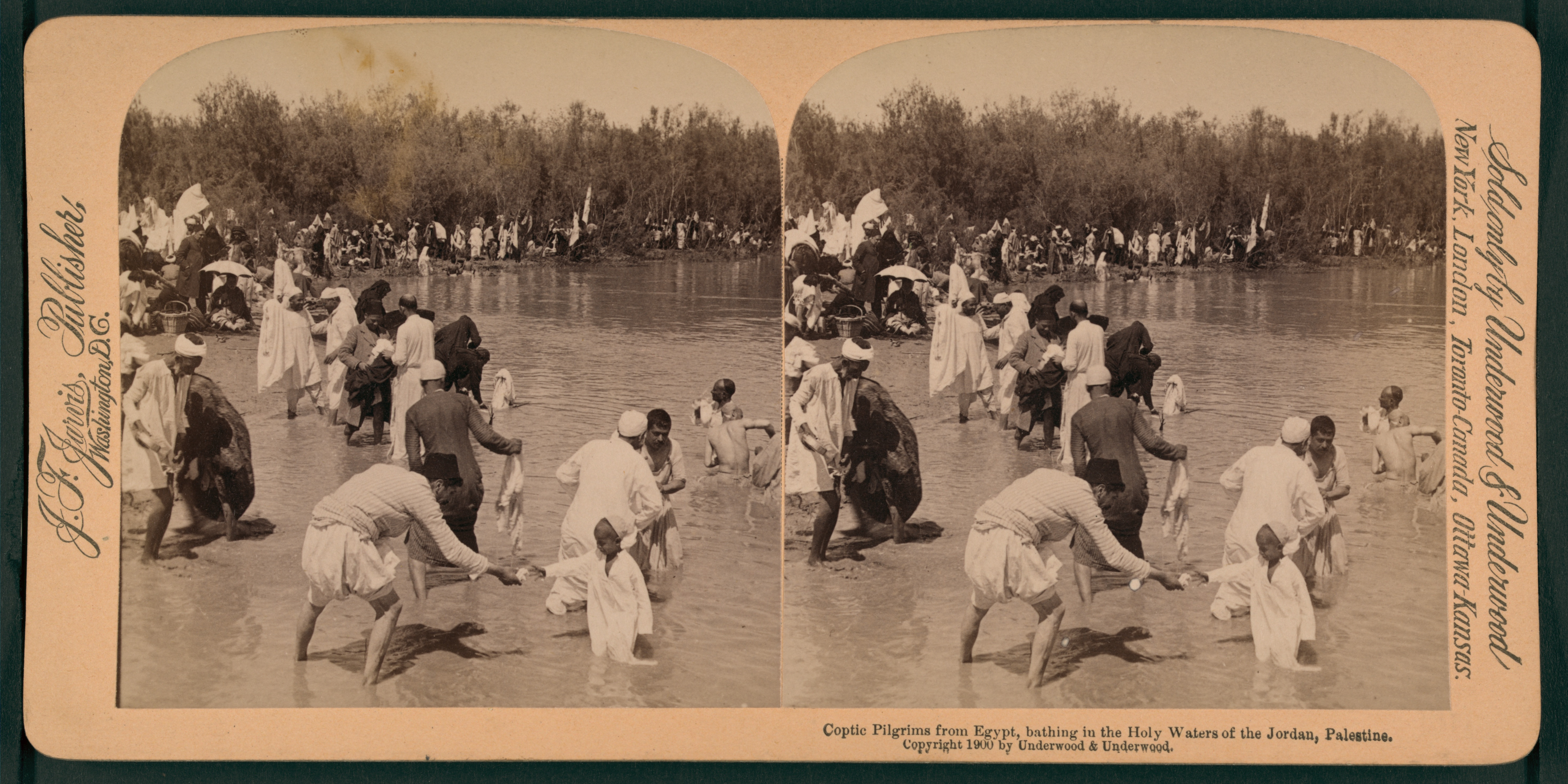
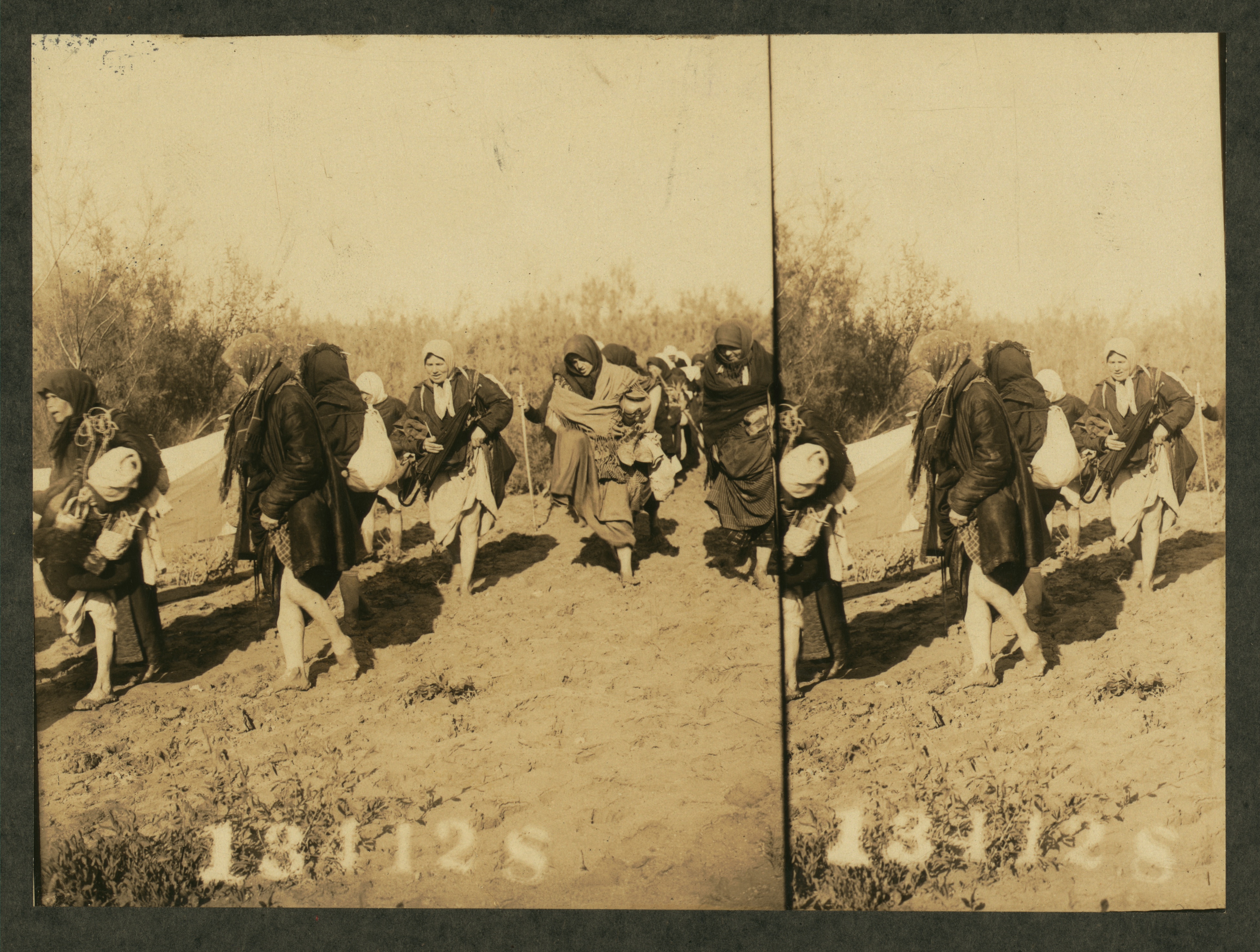
A 1913 stereograph distributed by Underwood & Underwood, a major US publisher of commercial stereographs, shows female pilgrims ankle-deep in the mud of the Jordan’s banks. The image was part of a commercial circuit in which Underwood & Underwood licensed and purchased negatives depicting the Holy Land from local studios, including the American Colony in Jerusalem, a prolific photographic enterprise that operated under late Ottoman sovereignty and continued into the British Mandate.12 Photographers and publishers circulated such stereographs widely in Europe and North America, framing the river as a biblical landscape for devotional consumption. Pilgrimage, profit, and territorial imagination converged in the same frame. An earlier stereograph, made in 1900, depicts Egyptian Coptic pilgrims at the Jordan.13 In both images, bodies move through the shallows without constraint.
It was at al-Maghtas that John the Baptist was said to have baptized Christ, and it is this point that draws the pilgrims to the water each year, as it has for centuries.14 To be baptized is to be immersed: to enter the water wholly and emerge changed. The pilgrims photographed here submit their bodies to the water for their own devotion and salvation; immersion here is rite and rebirth, a passage they choose to enter.
Many early American Colony images were stereographs. Held to the eyes, the paired photographs plunge the viewer into an illusion of depth, offering the sensation of standing within the scene, at the river’s edge or even in the water, without leaving one’s parlor. Yet the sensation of presence depends on separation; the two images must remain slightly apart. The pilgrims stand in the Jordan; the Western observer is immersed in the image of them.
Sold door to door by publishers like Underwood & Underwood, the stereograph packaged the Jordan as a devotional commodity: simulated presence at a site, purchasable by people who would never travel to it. In this circulation, it offered the river as a scene to be held in the hand and inspected from afar. It gave portable form to what Timothy Mitchell calls the “world-as-exhibition”: places set out as pictures for an observer who stands outside them, so looking can pass for knowing and the people in the scene become part of the display.15 Its depth was real to the eye, but it brought its viewers no closer to truly knowing the people pictured.
The American Colony itself began as a religious experiment. In 1881, Anna and Horatio Spafford, Chicago evangelicals shattered by personal tragedy, led a small band of “Overcomers” to Jerusalem, convinced that the Holy City would be the stage for the Second Coming.16 In 1896, the Colony was transformed by the arrival of Swedish converts, some from the farming village of Nås in Dalarna, others from a Swedish immigrant congregation in Chicago that Anna Spafford had persuaded to join her. They made the Colony predominantly Swedish American.17 Among the children they brought with them was G. Eric Matson, later one of the Colony’s leading photographers.
Necessity soon pushed the group from devotion into commerce: they opened a hostel, a store near the Jaffa Gate, and, in 1898, a photography service. Stereographs of holy sites and tableaux of Bible scenes were sold to the swelling tide of Western pilgrims, which meant that the darkroom quickly paid the bills.18 An early breakthrough came that same year, when Colony photographers documented Kaiser Wilhelm II’s visit to Palestine and marketed the images in Europe.19 In the photograph of his arrival at Haifa, the emperor himself can hardly be seen. The camera looks past the jetty and a diagonal line of flags set in the water toward the ships anchored offshore: imperial authority arrives by steamship at a landing place prepared for ceremony. Open water and sky fill most of the frame, and the picture could pass for a seascape, the kind of distant view painters had long sold to European buyers.20 Unlike a painting, though, it was formed by light from the scene registering on a photographic plate.21 The same picture could be sold as a Holy Land view and kept as a record of an imperial visit. That double use would serve the Colony well: in time, its camera would also record the work of the administrators and engineers who remade the Jordan River.
Over the following decades, the American Colony Photo Department’s clients multiplied. Its photographers shot for the Turkish Red Crescent during the First World War and, in 1917, recorded General Allenby’s entry into Jerusalem and the beginning of British rule.22 Under the Mandate, the studio turned increasingly from devotional scenes to aerial surveys, engineering commissions, and documentation for Zionist development funds eager to publicize “modern progress.”23 After the American Colony split in 1934, Matson and his wife, Edith Yantiss Matson, took over the Photo Department. In 1940, they renamed it the Matson Photo Service.24 What began as a millenarian record of pilgrimage became, in effect, a commercial photographic agency serving administrators, newspapers, militaries, and development enterprises. Those clients were reshaping the land by other means. Under the British Mandate, colonial authorities surveyed the river valley, determining which claims counted, how land could be valued and taxed, and where boundaries fell.25 The camera joined that work; it did not initiate it.
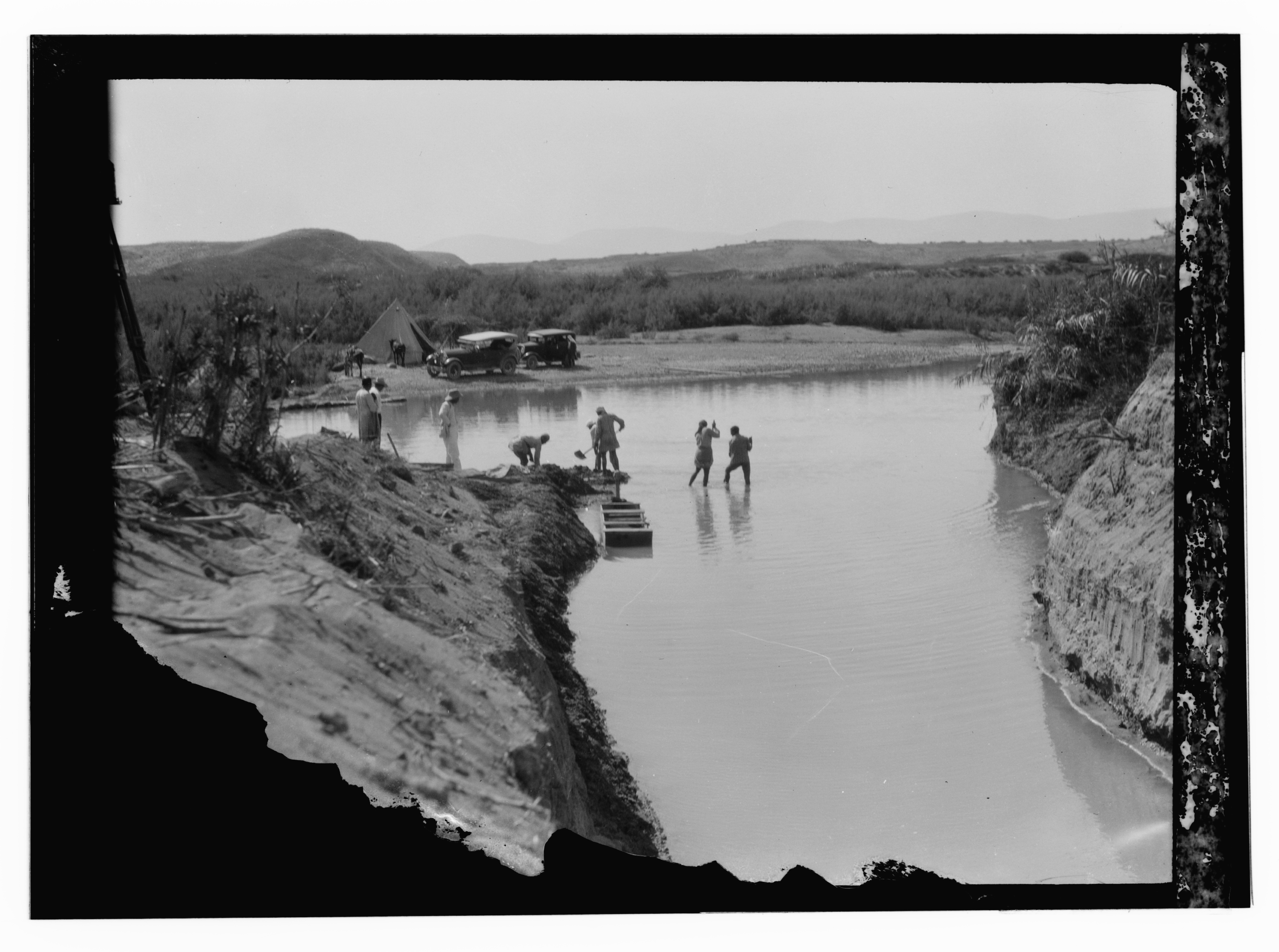
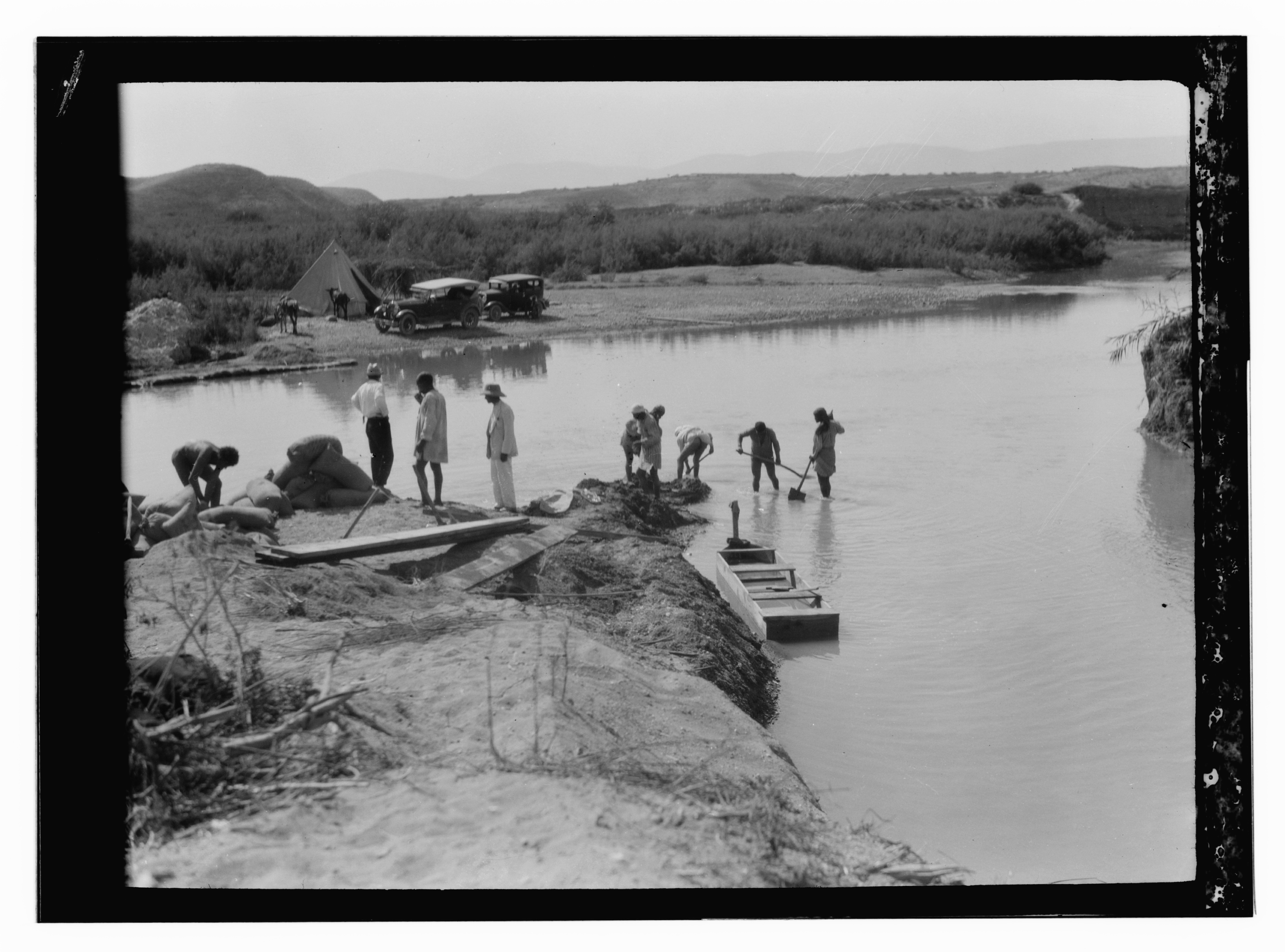
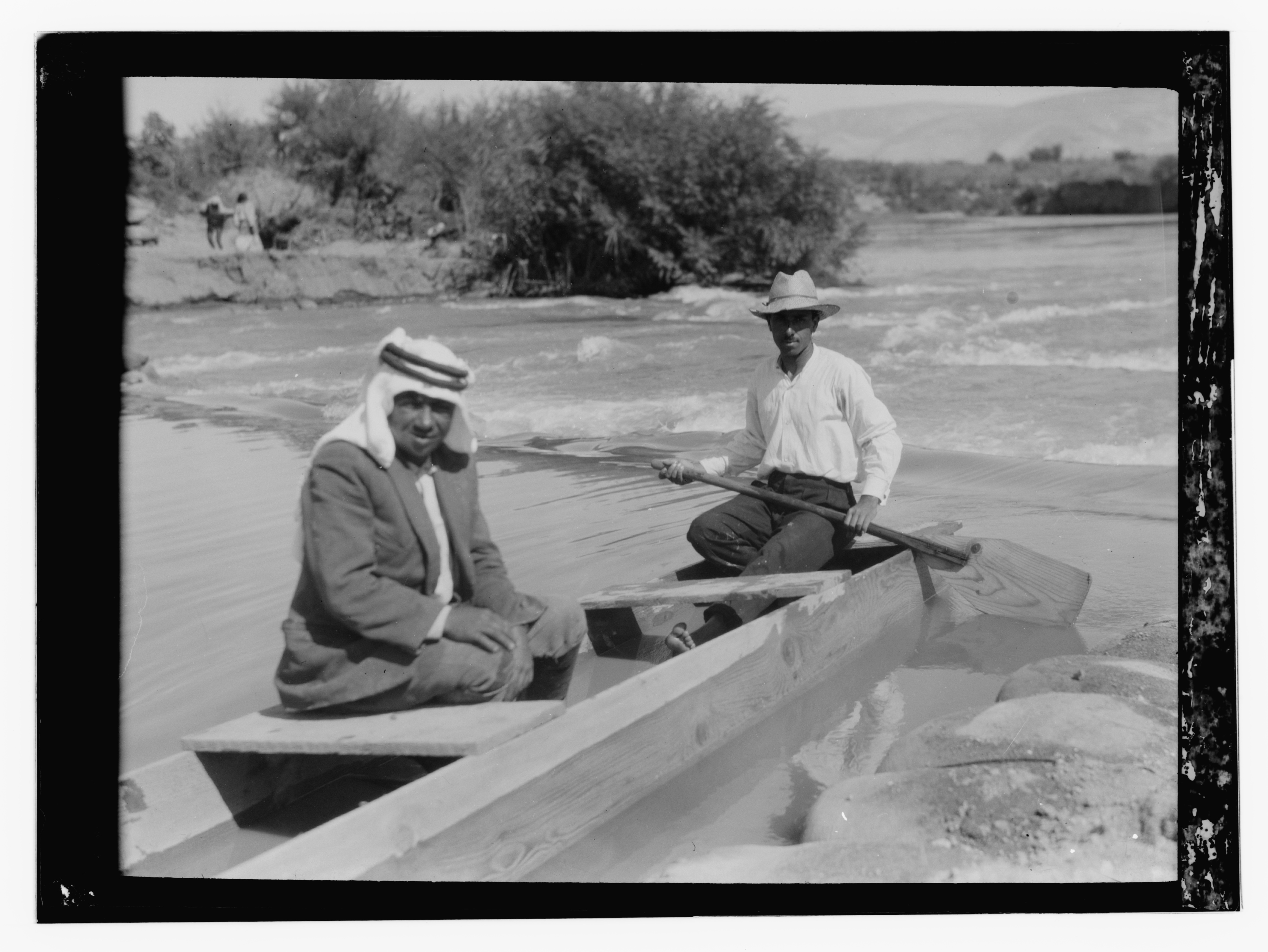
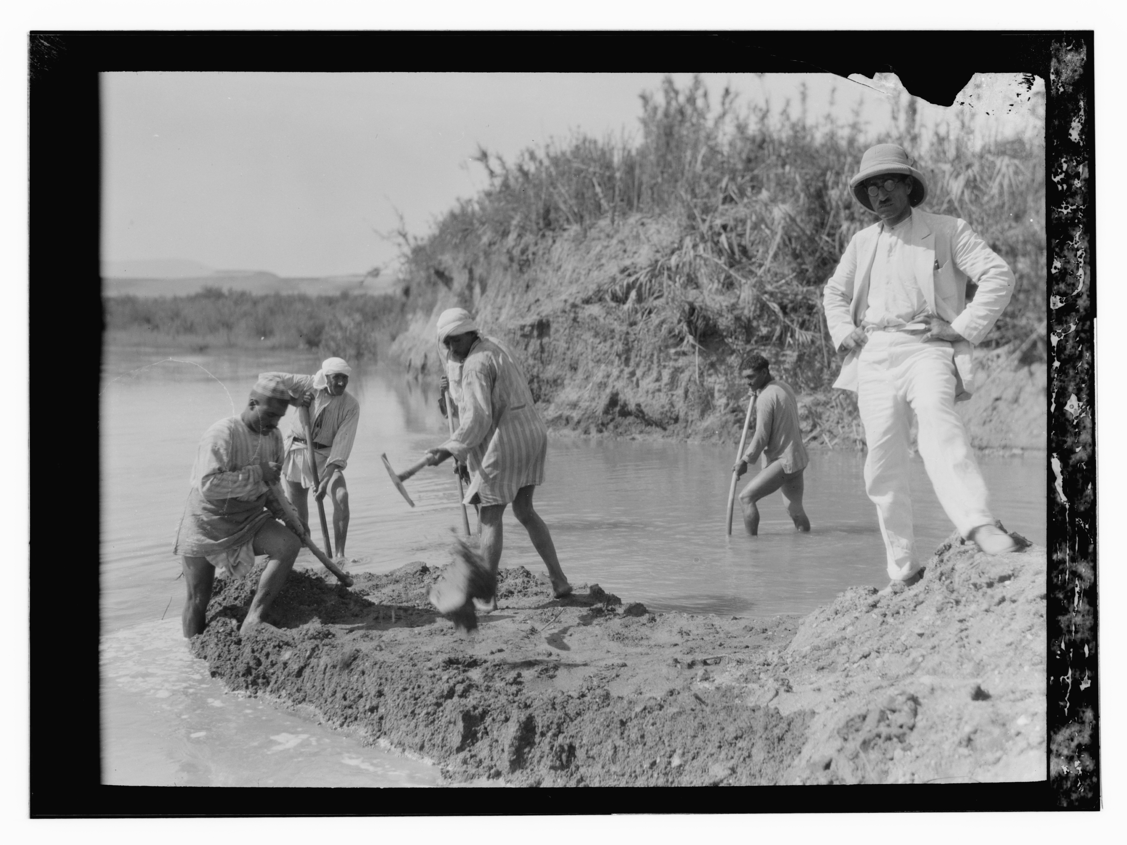
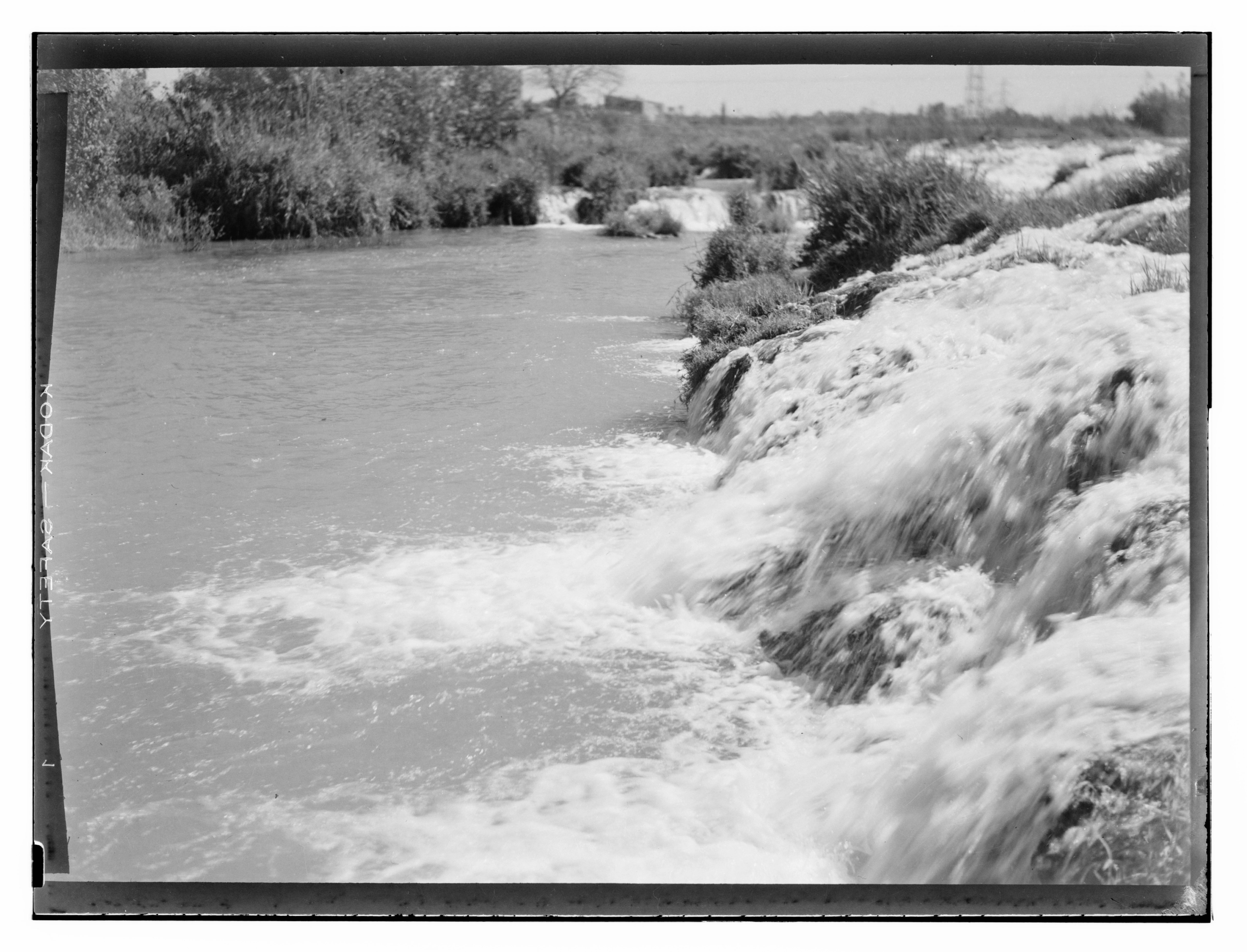
Some of the American Colony’s images of the Jordan make sense only when read together. In what is now the G. Eric and Edith Matson Photograph Collection at the Library of Congress, five consecutive negatives, numbered 13016 through 13020, dated by the catalog to between 1925 and 1946, sit filed under one generic title: “Jordan River.” Laid out in order, almost as a contact sheet, they document not a moment but an operation, a work party at a single bend of the river, recorded first at a distance and then progressively closer.26 Like a field report, the frames proceed from site, to intervention, to movement through the river, to the organization of labor, and finally to the behavior of the water itself.
The first frame stands back to show the whole site. Men work in and beside a cut channel. Sandbags, timber, and disturbed earth line the near edge, a rectangular wooden structure projects from the bank, and a tongue of freshly dug soil pushes into the water. On the far bank, a tent and two automobiles mark the presence of a field party. The scene reads less like ordinary life along the river and more like a temporary worksite: equipment, transport, shelter, and labor have been brought to one place to do one job. The photographer leaves a great deal of empty water in the frame. The subject is not just men, but men working on a river.
The next frames move closer and sort the operation into its parts. In one, laborers bend to the channel’s edge, digging and shifting the earth, sandbags accumulating at the left. In another, two men cross a faster stretch of water in a small boat. And in the closest frame, the camera moves in on the same work party: men in the river itself, one swinging a pickax at the bed, another plunging a long pole vertically into the water, probing the bed beneath him, others building up a mound of excavated earth. They have hitched their galabias up over wet legs; they are barefoot, bent, mud-streaked, caught mid-motion, the swung pickax and the flung earth blurring across the exposure.
On the right of this frame, raised on the dry bank above the men, stands a figure who does none of these things. He wears the field uniform of expertise: a pale suit unblemished by the mud that cakes the men below him, a sun helmet, spectacles, his shoes clean in counterpoint to the workers’ bare and muddied feet. He holds no tool. He faces the camera, hands on hips, weight cocked back, posed. Because he alone is still, the camera renders him sharply while the laboring bodies dissolve into their own motion. The catalog does not name him, and I would not assume from his dress alone that he was European rather than a local overseer or engineer in colonial garb, just as I would not assume where the men in the water were from. What the frame stages is not a nationality but a hierarchy, and it builds that hierarchy from posture and position rather than from any label: labor below, in the water, wet and bent and watched; authority above, on the bank, dry and clean and posed.
It is also a hierarchy of looking. He stands where the camera stands on the bank above the work. The laborers are overseen twice over, by the man above them and by the camera that shares his place, and they look back at neither. The blur obscures their faces, and the catalog names none of them. In the baptismal images, entering the water was the rite; here, standing in it is the job. What the immersion transforms is not the men but the river. The men in the water do the work; what the river should become is decided on the bank.
The sequence ends by removing people altogether. The camera turns to the water itself, fast and broken over a shallow drop in the riverbed. The men may have been reinforcing the bank, constructing a temporary barrier to hold or divert the current, or carrying out some other form of channel work. The catalog does not identify the purpose of the intervention, nor does it name the photographer: it attributes the negatives either to the American Colony Photo Department or to its successor, the Matson Photo Service.
What survives are the negatives, their numbers, and their passage into the collection. The negatives establish that a photographer documented the operation and did so systematically; whether the photographs served the work or merely accompanied it, the record does not say. The camera sees the intervention closely enough to catch a pickax blurring mid-swing, yet it cannot tell us what the intervention was for. It makes the labor visible while leaving both its purpose unstated and its laborers unnamed.
Whatever the work was, it took place in the decades when the river’s course had become a problem for the Mandate government. In 1922, Britain made the Jordan River the administrative boundary between Palestine and Transjordan, tying a political line to a river that did not hold still.27 In February 1927, a sudden shift in the river’s course moved the Jordan River some five hundred meters in the Beisan subdistrict, leaving roughly eight hundred dunams, or about eighty hectares, of land that had previously lain west of the river on the eastern side of its new channel. British officials then had to determine whether the boundary remained in the abandoned riverbed or moved with the water. They chose the latter.28 Before officials could allocate or engineer the river, they had to locate it, and it kept moving.
I cannot say what the work in the five negatives was for, or whether it had anything to do with the boundary. But they belong to the same moment, when the riverbed itself was becoming an object of increasingly exact attention.
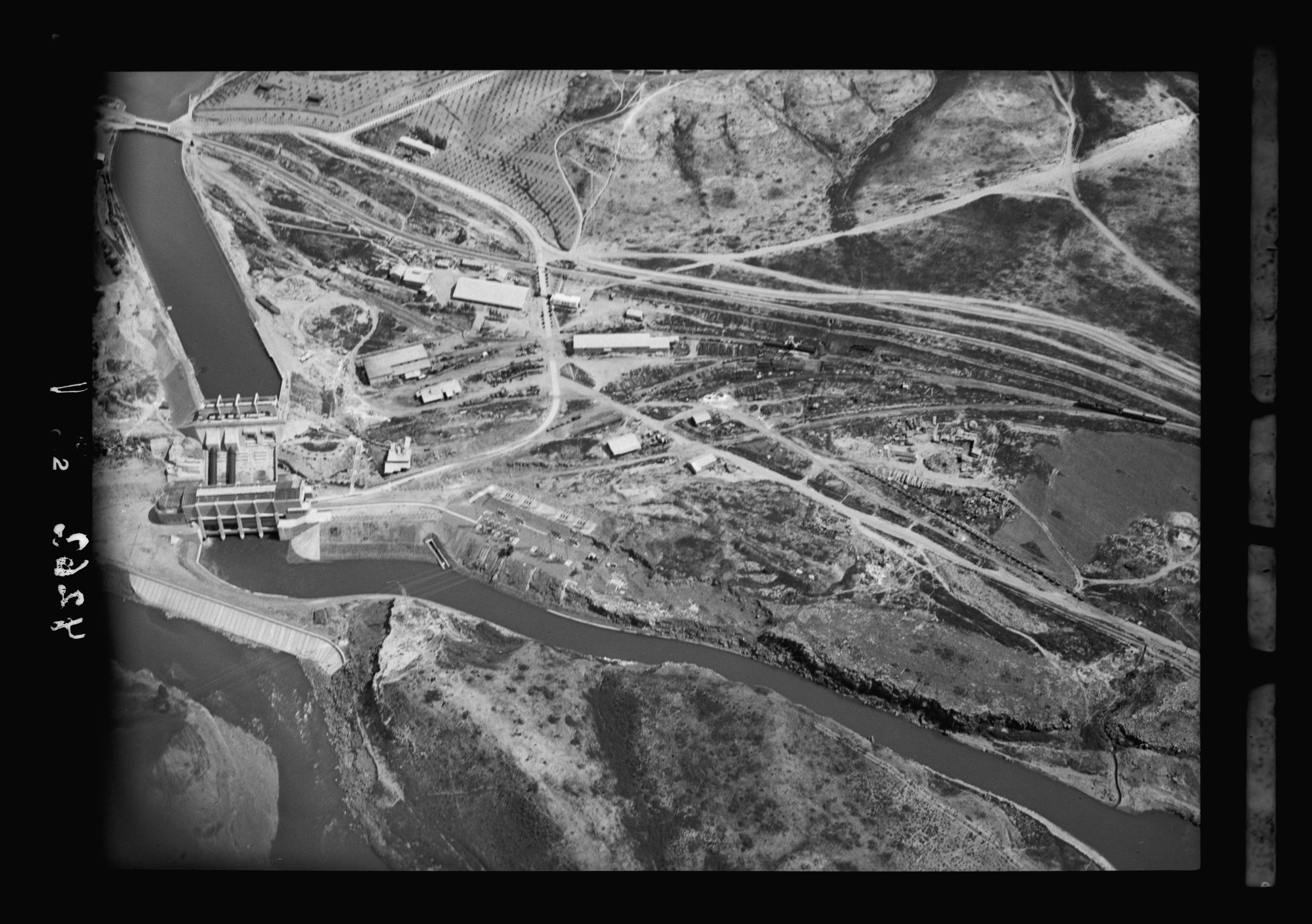
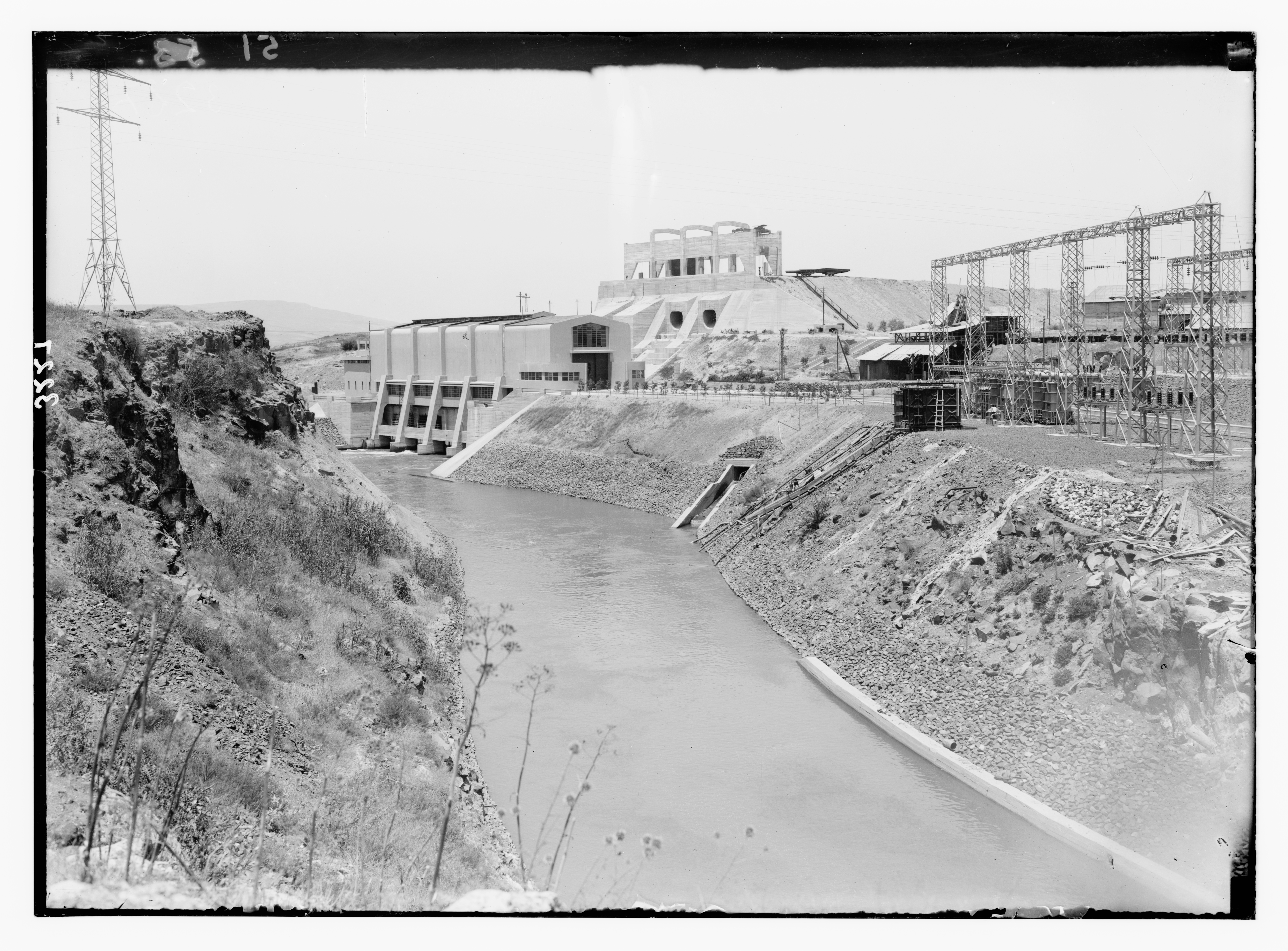
If the boundary made the river a line to fix, the decade that followed made it a source of power. In the early 1930s, the American Colony’s photographers documented, both from the air and on the ground, the works the hydroelectric entrepreneur Pinhas Rutenberg built at Jisr Majami’a (Naharayim). His Palestine Electric Corporation held a concession, agreed with the British government in 1921 and formalized in 1926 for seventy years, to use the waters of the Jordan and the Yarmuk to generate and distribute electricity.29 The plant began operating there in 1932. An aerial photograph from October 1931 lays out the Palestine Electric Corporation’s works as a system of parts: the tail-race canal, power station, workshops, and the engineered course of the water between them.30 From above, the river could be read through the terms set by the corporation and the Mandate government: as a concession, an investment, a project already half built. On the ground, the work had already reshaped the land. A photograph of the tail-race canal from about 1932 shows the power station in the background and, in front of it, a channel that engineers had cut through the terrain and lined with concrete and stone to hold the water.31
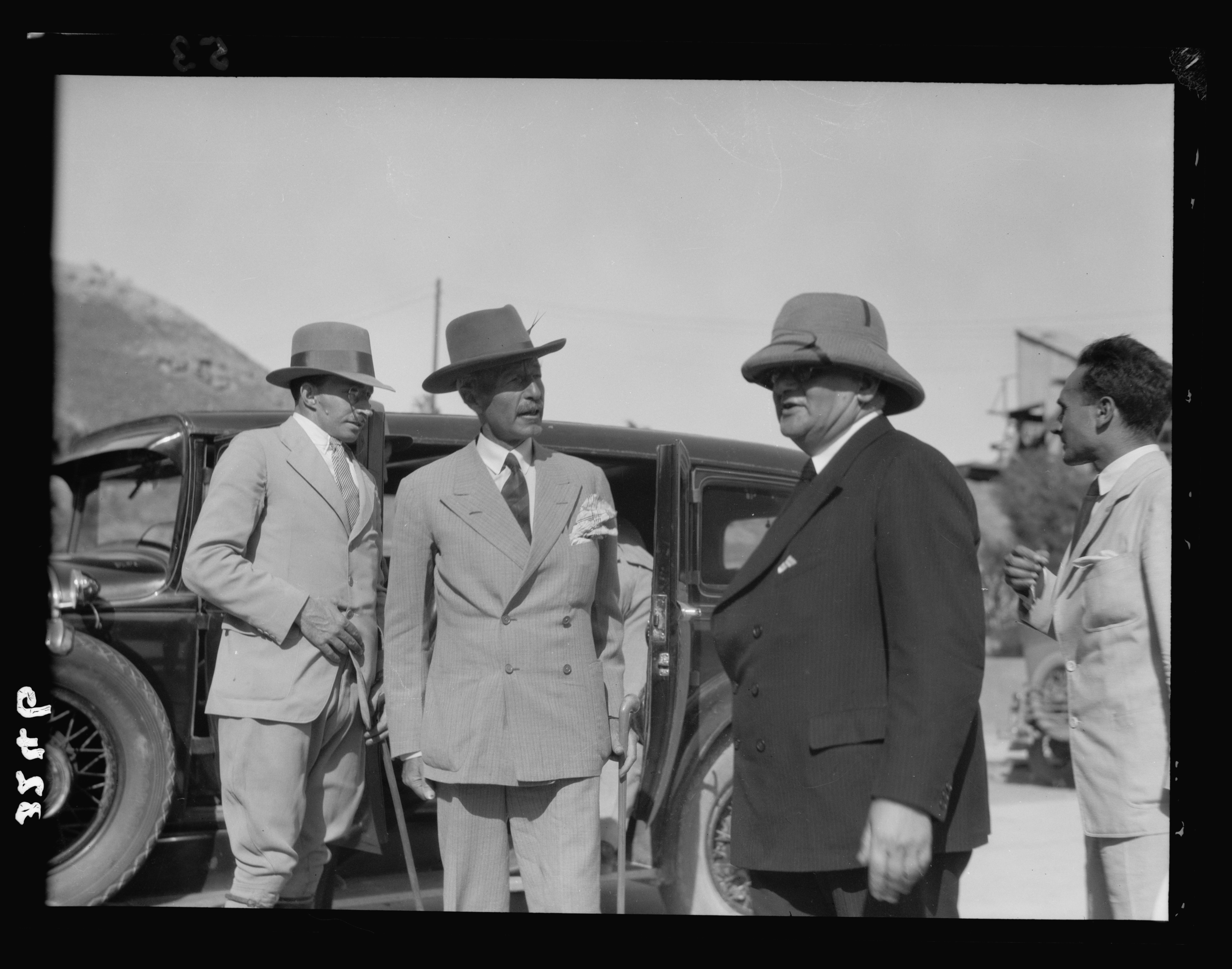
At the inauguration of the Jisr Majami’a plant, the river recedes still further from the frame. British High Commissioner Arthur Wauchope and Rutenberg stand in tailored suits beside motorcars as they formally open the facility, while the water itself is barely visible. Across these images, the terms of visibility shift: earlier photographs registered the river through bodies immersed in it; the aerial view renders it as a system; the tail-race photograph grounds that in concrete and stone; and the inauguration returns human figures to the frame as officials who preside over a river transformed into infrastructure.
Equally striking in the American Colony and Matson images of the Jordan is what they seldom show. The American Colony photographed the river as a sacred site and then, more and more, as a worksite: laborers in the channel, the machinery of “modern progress.” The river as an ordinary place in the lives of the people who lived along it rarely enters the frame: farmers drawing on it to water their fields, families washing and gathering at its edge, neighbors crossing along its banks, children swimming in it for no reason but pleasure. This absence does not mean that such life had disappeared. At this stage, what is missing is the image, not the life. The studio photographed Palestinian daily life, but usually as picturesque or ethnographic images, arranged for an outside viewer. The archive does not give us the kind of image a family makes of itself: one whose significance lies not in explaining its subjects to an outside viewer but in remembering who was there. Those images survive elsewhere, in photographs Palestinian families made and kept.32
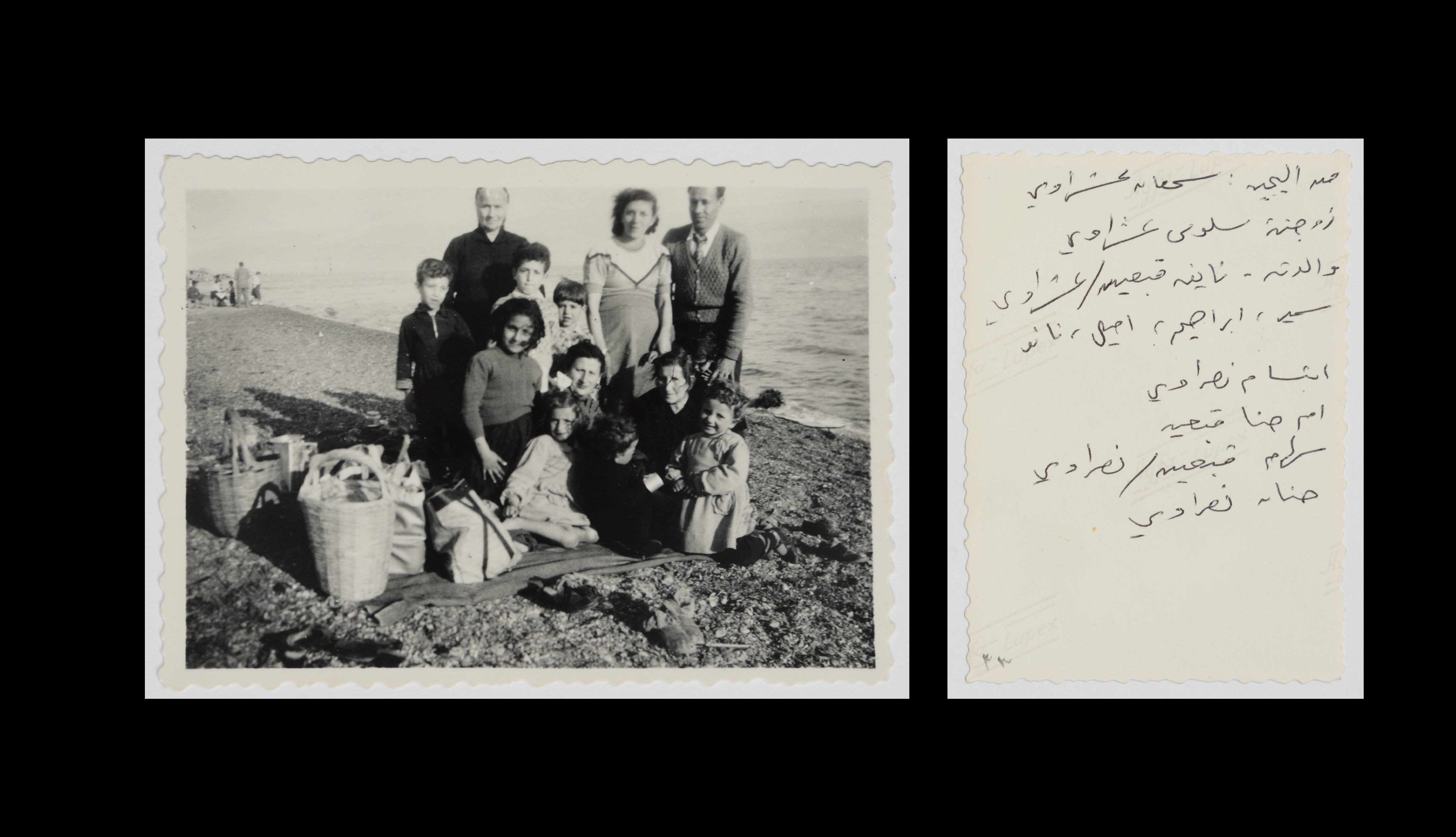
Among them are photographs of a 1955 outing the Ashrawi family made to the Jordan, now held in the Palestinian Museum’s digital collections.33 In one, adults and children sit loosely arranged on a pebbled bank before the open water, woven baskets and cloth bags set down on the stones beside them. They are not posed before a famous site; they have settled in for a while by the bank, sat down and placed their belongings there. The river here is neither sacred geography nor hydraulic object. It is a place where a family spends the day.
The difference between this archive and the colonial one is not that one contains people and the other does not. The American Colony photographed many Palestinians. But this institutional archive makes people legible according to the purposes of the institution: as pilgrims, as types, as labor, as the population of a district. This family album preserves people according to the relationships internal to the family itself. The institutional record shows exactly what a work party did to one bend of the river, even when it cannot say why, while letting the men who did the work go unnamed. This album does the reverse: it records who the people are—Naifah, Salwa, Sama’an—and the children gathered around them, while what they were doing was nothing more remarkable than spending a day by the water. The album records an ordinary outing. Read now, it also preserves a claim of presence: we were here.
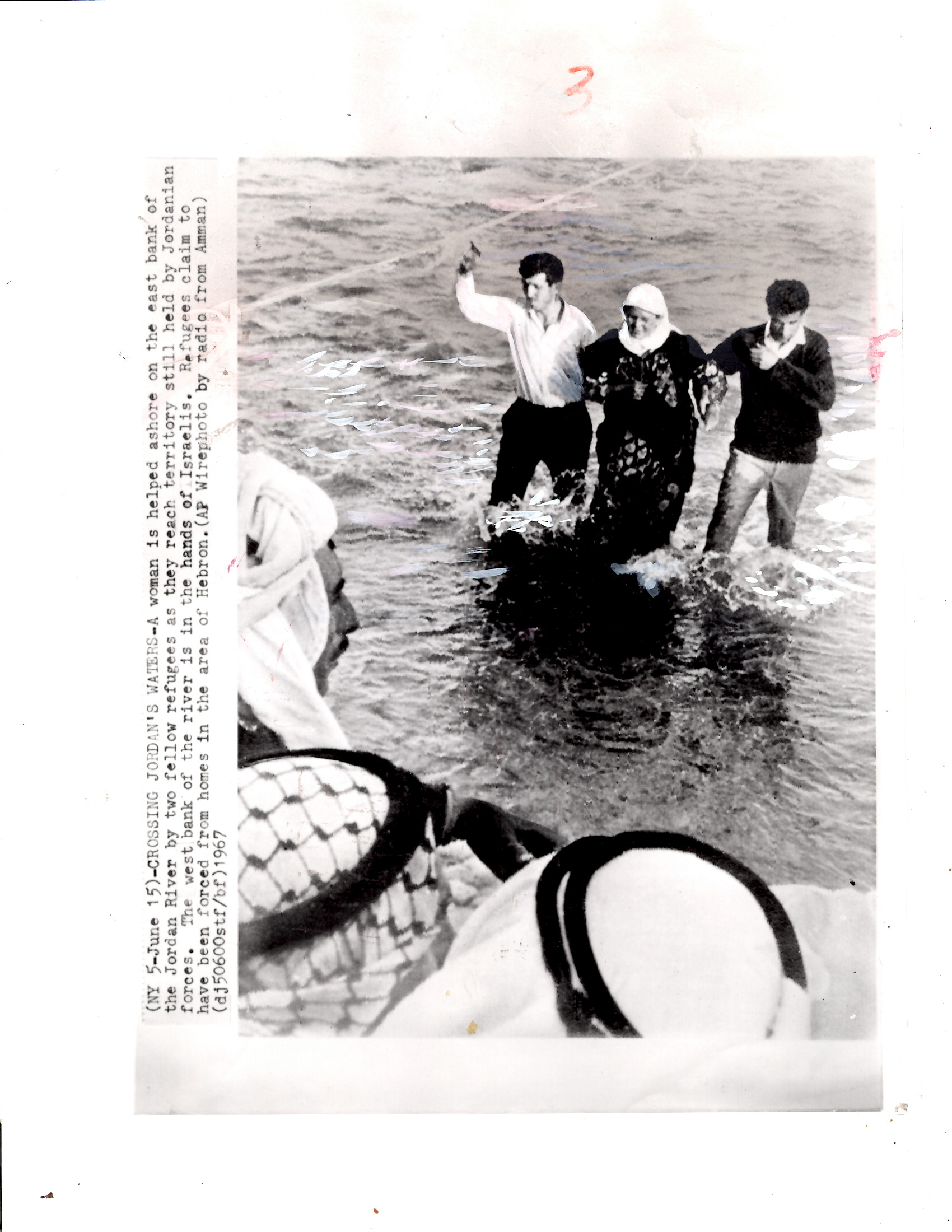
Twelve years later, the same river appears in a photograph of a very different kind. Taken in June 1967, during the war, it shows a woman fleeing al-Khalil (Hebron), which Israeli forces had occupied, wading across the Jordan toward the Jordanian-held east bank, with two others helping her through the current.34 She was one of some 200,000 people who crossed the river from west to east that summer.35 The original publication and the photographer are unknown. Unlike in the Ashrawi photograph, no one has gathered for the camera here, and nothing has been set down on the bank. She enters the same water the pilgrims once entered for rebirth, not as a rite, nor as labor, but as an escape. During the war, the river where a family had once spent a day at ease became, for those driven from their homes, a line to flee across. Behind her, home is already becoming occupied ground; ahead lies uncertainty.
Upstream, Israel and Jordan had already transformed the river’s flow. Before the 1950s, Lake Tiberias released an average of 605 million cubic meters a year into the lower Jordan. By the mid-1960s, Israel’s National Water Carrier was pumping water out of the lake, while Jordan’s East Ghor Canal was drawing water from the Yarmuk, the Jordan River’s largest tributary. Israel had also rerouted saline springs into the river below the lake, so what reached the lower river was a trickle, and a salty one.36 By around 2000, inflow to the Dead Sea had fallen to about a fifth of the river’s historical volume.37 The 1994 Israel-Jordan peace treaty formalized bilateral allocations and arrangements over Jordan and Yarmuk waters; Palestinians were not a party to the treaty.38
For Palestinians in the valley, the consequences are still felt today. After 1967, they lost the pumps and wells they had used along the river, and a military order required Israeli permits for any new water installation, which the authorities rarely granted. Israeli wells in the valley now supply its settlements and their farms, while many nearby Palestinian communities must buy water that is trucked in at several times the price.39
As the river’s flow diminished, Israel also restricted access to stretches of its western bank. From the late 1960s into the early 1970s, it laid minefields along the river frontier with Jordan; from the 1970s onward, it designated extensive areas of the valley as closed military areas and firing zones.40 At Qasr al-Yahud, the baptism site on the western bank facing al-Maghtas across the water, the minefields sealed off the surrounding churches, monasteries, and adjacent land for more than fifty years. The contrast with the 1900 stereograph is stark. There, the Coptic pilgrims enter the Jordan without visible constraint; at Qasr al-Yahud, later pilgrims reached the river only along a cleared corridor through mined ground.41 The question was no longer only how much water remained, but who could reach the river at all.
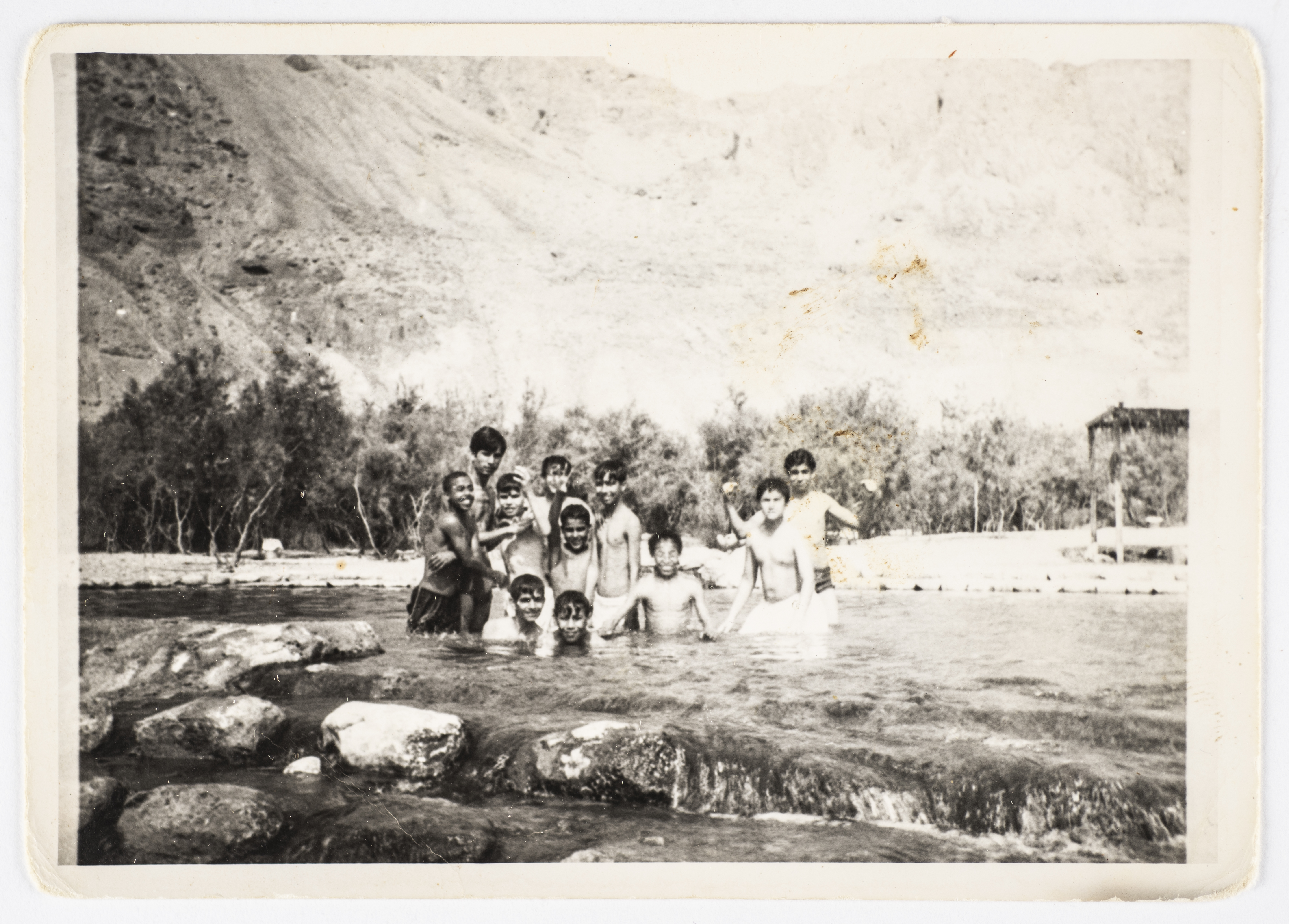
Yet neither the 1967 war nor the minefields ended Palestinian life along the river’s waters at once. In the years that followed, Palestinians still came to the valley’s springs and riverbanks, even as the conditions for reaching them narrowed. A photograph preserved in the Palestinian Museum Digital Archive shows Musa Sanad with his students in 1971 at ‘Ein al-Fashkha, a spring on the northwestern shore of the Dead Sea, a few kilometers south of where the Jordan ends: twelve boys stand waist-deep in the springs, laughing.42 Set beside the Matson negatives, the photograph breaks with how other images in this essay show people in water: as pilgrims, laborers, or objects of observation. The same waist-deep posture that the American Colony camera had rendered as labor appears here as pleasure and belonging. The photograph records one day of that access, bodies caught mid-play.
The springs are not part of the Jordan River, but they discharge into the same terminal sea whose level has fallen sharply as upstream diversions reduced inflow.43 The photograph belongs here not as evidence of access to the Jordan, which it does not show, but as evidence of what the institutional archive hardly recorded: an ordinary, continuing relation to water in a landscape already under enclosure. Two years before this photograph was taken, Israel had confiscated 97 dunams of land from the village of al-’Ubeidiya at ‘Ein al-Fashkha.44 The site is now a nature reserve, one of several designations, alongside firing zones and settlement areas, that restrict Palestinian land use across the Jordan Valley and northern Dead Sea region. In 2017, B’Tselem estimated that Israel barred Palestinians from entering or using roughly 85 percent of that area.45 What the photograph holds, then, is not an afternoon outside that history but one taken inside it: boys in the water at a site Israel was already enclosing around them.
Across the photographs and songs discussed here, the Jordan appears in three relations: a river imagined from afar by people who could not reach it; a river rendered as sacred spectacle, territory, worksite, concession, and hydraulic system, even when the people in the frame stood in its water; and a river lived close at hand, by the Ashrawi family who sat beside it and the refugee who crossed it in flight. Surveyors, engineers, administrators, and military authorities turned ways of living with the river into forms of control, transforming closeness into distance. Photography served that process in two ways. It let buyers in European and American parlors own the river as an image, apart from the people who lived along it. Detached from those lives, the river became easier to picture as something others could claim. Photography also made the river legible to the institutions that fixed it as a boundary, channeled its power, diverted its flow, and closed its banks. The American Colony’s pictures moved between parlor and office. In the archive that now holds them, the distance persists: the work party appears under “Jordan River,” with none of the men named.
Family snapshots, now kept in a Palestinian archive, preserve what enclosure would take away: a day on a pebbled bank, boys laughing as they wade waist-deep in the spring. They show that the closeness existed, and whose it was. Yet they hold only a fragment of it. To lose a river is to lose more than water. It is to lose the fields it watered, the crossings it allowed, the gatherings it held, the relatives on the other bank. The river still runs, diminished, and no photograph or song can restore the conditions of that life.
Today, at Qasr al-Yahud, an Israeli-run site in the occupied West Bank, pilgrims again step down into the Jordan from stone terraces built for them, the ritual of the stereographs restaged inside a managed enclosure. Nearby, Palestinian farmers are barred from drawing water from the river.
The river of which enslaved African Americans sang as a symbol of deliverance is the river Palestinians are now kept from. The histories of Black enslavement and Palestinian dispossession remain distinct, but set near each other, they show colonial power working through property: human beings bought, sold, and worked for profit; land and water surveyed, seized, and granted as concessions.46 The question, then, is not only what the Jordan has been made to mean, but who may still touch its waters.
This essay grew out of a lecture-performance incorporating poems from the author’s artist publication Blue-Black Liver (2025), presented at Agit, Berlin, and Tintera, Cairo, as part of the public program accompanying her 2025 exhibition Blue Black at Künstlerhaus Bethanien, Berlin.
-
William Francis Allen, Charles Pickard Ware, and Lucy McKim Garrison, Slave Songs of the United States (New York: A. Simpson, 1867; repr., Mineola, NY: Dover, 1995). ↩
-
In some songs, the Jordan is the boundary of death, the river crossed to reach heaven; in others, it marks entry into the Promised Land; in later interpretations, it has often been read as a route of escape from bondage in this life. These readings are not mutually exclusive, and a single performance could hold more than one. On “Roll, Jordan, Roll” as a song of collective mourning, sung in Steve McQueen’s 12 Years a Slave over the grave of a man worked to death, see Shana L. Redmond, “Tip Toes and River Rolls: Overhearing Enslavement,” Black Camera 7, no. 1 (2015): 150–161. On debates over whether the spirituals oriented enslaved people primarily toward otherworldly deliverance or also articulated this-worldly desires for freedom and resistance, see Lawrence W. Levine, Black Culture and Black Consciousness: Afro-American Folk Thought from Slavery to Freedom (New York: Oxford University Press, 1977), esp. chap. 1; and John Lovell Jr., Black Song: The Forge and the Flame (New York: Macmillan, 1972). ↩
-
United Nations Office for the Coordination of Humanitarian Affairs, West Bank: Movement and Access Update, August 2011, section V, “The Jordan Valley Area.” OCHA notes that approximately 10 percent of the Jordan Valley had been designated a military “buffer zone” along the Jordan River, where Palestinian access was prohibited under the applicable closure regime. See also United Nations Secretary-General, “Israeli Settlements in the Occupied Palestinian Territory, including East Jerusalem, and in the Occupied Syrian Golan,” A/HRC/25/38, February 12, 2014, para. 22, noting that Palestinians are denied access to the Jordan River’s banks. OCHA’s December 2025 West Bank Access Restrictions map, published April 23, 2026, continues to mark a “Jordan Valley Military Buffer Zone” within the West Bank’s closed and restricted areas. ↩
-
Patrick Wolfe distinguishes the dominant logics of slavery and settler colonialism by arguing that enslaved people were valued as labor and property, since their reproduction could augment their owners’ wealth, whereas Indigenous presence obstructed settler access to territory, generating what he calls a logic of elimination. He links these divergent relations to hypo-descent in the case of Black people and blood quantum in the case of Indigenous peoples. See Patrick Wolfe, “Settler Colonialism and the Elimination of the Native,” Journal of Genocide Research 8, no. 4 (2006): 387–409, esp. 388; and Wolfe, Traces of History: Elementary Structures of Race (London: Verso, 2016). Wolfe later applied this framework to Palestine in “Purchase by Other Means: The Palestine Nakba and Zionism’s Conquest of Economics,” Settler Colonial Studies 2, no. 1 (2012): 133–171. Fayez Sayegh had made a related, though not identical, argument decades earlier, contrasting European settler regimes that retained Indigenous populations as subordinated labor with a Zionist project marked by segregation, exclusion of Arab labor, and displacement from the land. See Fayez Sayegh, Zionist Colonialism in Palestine (Beirut: PLO Research Center, 1965), repr. in Settler Colonial Studies 2, no. 1 (2012): 206–225. ↩
-
Mustafa Abbasi, “City of Farmers and Merchants: Beisan in the Palestine Mandate Period (1918–1948),” Journal of Holy Land and Palestine Studies 14, no. 2 (2015): 205–206, 214, link. Abbasi describes the agricultural life of late Ottoman Beisan, including irrigation works and movement across the Jordan. For the broader valley, see Atwa Jaber, “The Israeli Annexation of the Jordan Valley: Exploring a History of Settler-Colonial Expansion,” in De/Colonising Palestine: Contemporary Debates, ed. Riccardo Bocco and Ibrahim Saïd (Geneva: Graduate Institute Publications, 2025), 105–128, esp. 105, link. Jaber emphasizes the Jordan Valley’s long-standing agricultural productivity and its role as a place of crossing east. ↩
-
On the river under late Ottoman rule, see Eugene L. Rogan, Frontiers of the State in the Late Ottoman Empire: Transjordan, 1850–1921 (Cambridge: Cambridge University Press, 1999). On the 1922 boundary, see League of Nations, “Article 25 of the Palestine Mandate: Territory Known as Trans-Jordan. Note by the Secretary-General,” September 23, 1922, C.667.M.396.1922.VI. On the Jordan–Yarmuk hydroelectric scheme, see Great Britain, Report by His Britannic Majesty’s Government on the Administration Under Mandate of Palestine and Trans-Jordan for the Year 1923 (London: HMSO, 1924), which records the 1921 agreement to grant Pinhas Rutenberg a concession for generating electricity from the waters of the Jordan and the Yarmuk. On the later diversions, see Rémy Courcier, Jean-Philippe Venot, and François Molle, Historical Transformations of the Lower Jordan River Basin (in Jordan): Changes in Water Use and Projections (1950–2025), Comprehensive Assessment of Water Management in Agriculture Research Report 9 (Colombo: International Water Management Institute, 2005), 12–14. On post-1967 military closures, see UN OCHA, The Humanitarian Impact of Israeli-Declared “Firing Zones” in the West Bank, August 2012. These developments are discussed further below. ↩
-
A stereograph consists of two photographs of the same subject taken from slightly offset positions, usually with a dual-lens camera set roughly eye-distance apart, about six centimeters. Once the images are placed side by side and viewed through a stereoscope, each eye perceives only its matching image, and the brain merges them into a three-dimensional view. The principle was first demonstrated in 1838 by Charles Wheatstone; in the 1850s, David Brewster improved the apparatus and published a treatise on its history and mechanics. See David Brewster, The Stereoscope: Its History, Theory, and Construction (London: John Murray, 1856), chaps. 1–2; Charles Wheatstone, “Contributions to the Physiology of Vision, Part the First,” Philosophical Transactions 128 (1838): 371–394. ↩
-
Oliver Wendell Holmes, “The Stereoscope and the Stereograph,” Atlantic Monthly 3, no. 20 (June 1859): 738. On the stereoscope as a device that reorganized the relation between observer and the world in the nineteenth century, see Jonathan Crary, Techniques of the Observer: On Vision and Modernity in the Nineteenth Century (Cambridge, MA: MIT Press, 1990), esp. chap. 4. ↩
-
Walter Benjamin called the camera’s capability to show what the unaided eye cannot see the “optical unconscious”: as psychoanalysis brings to light impulses that pass unnoticed, the camera brings to light details too small to register and holds them still long enough to be studied. Surveyors put that ability to work, and in Palestine they did so early. The Palestine Exploration Fund, founded in London in 1865, brought biblical archaeology, photography, and military surveying into a single enterprise; its Survey of Western Palestine, carried out by the Royal Engineers in the 1870s, mapped the biblical landscape as measured terrain as far east as the Jordan. See Walter Benjamin, “Little History of Photography,” in The Work of Art in the Age of Its Technological Reproducibility, and Other Writings on Media, ed. Michael W. Jennings, Brigid Doherty, and Thomas Y. Levin (Cambridge, MA: Harvard University Press, 2008), 274–298; and, on the Palestine Exploration Fund, John James Moscrop, Measuring Jerusalem: The Palestine Exploration Fund and British Interests in the Holy Land (London: Leicester University Press, 2000). ↩
-
F. J. Salmon, “Cadastral Air Survey,” Empire Survey Review 4, no. 28 (1938): 336–337. Salmon, then Commissioner of Lands and Surveys in Palestine, reported that air surveying was used “for revision along the Jordan, where the banks have changed,” and credited the Royal Air Force with the flying. He also explained why the department continued to make its cadastral plans for land settlement on the ground, where boundaries were agreed with villagers and recorded in signed field books. Measurements and maps were produced from aerial photographs through photogrammetry; Salmon described plotting the Judaean Desert with a stereoscope. See also Dov Gavish, A Survey of Palestine Under the British Mandate, 1920–1948 (London: RoutledgeCurzon, 2005). ↩
-
I use “legible” in James C. Scott’s sense: a state’s capacity to simplify and standardize a landscape so it can be counted, taxed, and administered. See James C. Scott, Seeing Like a State: How Certain Schemes to Improve the Human Condition Have Failed (New Haven, CT: Yale University Press, 1998), esp. 2–3, 11–52. ↩
-
Underwood & Underwood, Pilgrims on the Banks of the Jordan Wading Through the Mud, stereograph (New York: Underwood & Underwood, ca. April 15, 1913), Library of Congress Prints and Photographs Division, LOT 13559, no. 28, digital file LC-DIG-ppmsca-05013. At its peak, Underwood & Underwood, founded in 1881 by brothers Elmer and Bert Underwood of Ottawa, Kansas, and headquartered in New York by 1890, issued some ten to twelve million stereographs annually. They did not shoot most of the “Holy Land” plates themselves but licensed or bought glass negatives from local studios, chiefly the American Colony Photographic Department, later the Matson Photo Service, folding those views into a global commodity stream; catalogues such as Travels Through the Holy Land and The World in Motion were sold in North America and Europe. For an overview of Underwood’s output and global network, see John Hannavy, ed., Encyclopedia of Nineteenth-Century Photography (London: Routledge, 2008), 1310–1311; on the company’s use of American Colony negatives, see Mia Gröndahl, The Dream of Jerusalem: Lewis Larsson and the American Colony Photographers (Stockholm: Journal, 2005), 258–261. ↩
-
J. F. Jarvis, Coptic Pilgrims from Egypt, Bathing in the Holy Waters of the Jordan, Palestine, stereograph, gelatin silver print (Washington, DC: J. F. Jarvis, April 27, 1900), copyright Underwood & Underwood, Library of Congress Prints and Photographs Division, LOT 13711-4 no. 239, digital file LC-DIG-ppmsca-10640. ↩
-
UNESCO World Heritage Centre, “Baptism Site ‘Bethany Beyond the Jordan’ (Al-Maghtas),” World Heritage List, inscribed 2015, link. UNESCO identifies the site as the location accepted by most Christian denominations as the place of Jesus’s baptism, documents religious activity there from the fourth to the fifteenth centuries, and notes that it continues to draw pilgrims who perform baptism rituals at the site today. ↩
-
Timothy Mitchell, Colonising Egypt (Cambridge: Cambridge University Press, 1988), chap. 1. Mitchell develops the idea from European encounters with the Middle East in the nineteenth century, when the world exhibitions trained visitors to experience places as representations arranged for an observer. ↩
-
Helga Dudman and Ruth Kark, The American Colony: Scenes from a Jerusalem Saga (Jerusalem: Carta, 1998), 19, 21. ↩
-
Library of Congress, “The Swedes,” American Colony in Jerusalem, Manuscript Division, link. ↩
-
Barbara Bair, “The American Colony Photography Department: Western Consumption and Insider Commercial Photography,” Jerusalem Quarterly 44 (2010): 29, 31, and 33–34. ↩
-
Bair, “The American Colony Photography Department,” 34. ↩
-
On the commercial circulation of painted views and their claims to authenticity, see Musée d’Orsay, “The Spectacular Art of Jean-Léon Gérôme (1824–1904),” exhibition text, October 19, 2010–January 23, 2011, sections “The Issues of Circulation” and “Gérôme’s Imaginary Orients.” On landscape and imperial power, see W. J. T. Mitchell, “Imperial Landscape,” in Landscape and Power, 2nd ed., ed. W. J. T. Mitchell (Chicago: University of Chicago Press, 2002), 5–34. ↩
-
William Henry Fox Talbot, one of the inventors of photography, imagined a photograph of a collection of china being shown in court after a theft. Talbot, The Pencil of Nature (London: Longman, Brown, Green, and Longmans, 1844–46), plate III, “Articles of China.” For the argument that a photograph’s authority as evidence came less from the image itself than from the institutions that used it, see John Tagg, The Burden of Representation: Essays on Photographies and Histories (Amherst: University of Massachusetts Press, 1988). ↩
-
Bair, “The American Colony Photography Department,” 34. ↩
-
Bair, “The American Colony Photography Department,” 35–36; Rebekka Grossmann, “The ‘Colonial’ Vantage Point: Imperial Photography in Mandatory Palestine,” Israel Studies 26, no. 3 (2021): 164. ↩
-
Gröndahl, The Dream of Jerusalem, 213. ↩
-
Great Britain, Colonial Office, Report by His Majesty’s Government in the United Kingdom of Great Britain and Northern Ireland to the Council of the League of Nations on the Administration of Palestine and Trans-Jordan for the Year 1930 (London: His Majesty’s Stationery Office, 1931), Department of Surveys. Paragraph 15 reports that by the end of 1930, the 1:10,000 survey covered the whole Jordan Valley except for a narrow strip between Wadi Fara‘a and the Beisan lands and identifies areas valued for the land tax; paragraph 19 describes cadastral procedures involving claims, claimants, parcels, and registration. ↩
-
G. Eric and Edith Matson Photograph Collection, Prints and Photographs Division, Library of Congress, negatives 13016–13020, filed under “Jordan River,” ca. 1925–1946, reproduction nos. LC-DIG-matpc-13016 through LC-DIG-matpc-13020. The sequence is a fact about the collection rather than about the photographer’s intention: the negatives are consecutively numbered and filed together under a single title, and I read them in the order in which they are preserved in the archive. ↩
-
Great Britain, Colonial Office, Report by His Majesty’s Government in the United Kingdom of Great Britain and Northern Ireland to the Council of the League of Nations on the Administration of Palestine and Trans-Jordan for the Year 1938 (London: His Majesty’s Stationery Office, 1939), 1. ↩
-
On the legal conventions governing river boundaries and the British decision in 1927 to adopt the Jordan’s thalweg and allow the boundary to move with shifts in its channel, specifically, see Richard Schofield, “Locating the Channel and Other Tales from the River Bank: Constants and Change in River Boundary Delimitation,” Water International 47, no. 6 (2022): 987–988. On the 1927 avulsion and its effects on local landholding, see Yitzhak Gil-Har, “Boundaries Delimitation: Palestine and Trans-Jordan,” Middle Eastern Studies 36, no. 1 (2000): 77–78. Gil-Har notes that the eight hundred dunams transferred by the river’s new course were pasture belonging to the Gazawiyeh Bedouin, and that between 1927 and 1944, five cases of channel change moved strips of land from one jurisdiction to the other. ↩
-
On the concession, signed in 1921 and formalized on March 5, 1926, see A Survey of Palestine, vol. 2 (Jerusalem: Government Printer, 1946), 973. On the plant’s construction and its opening on June 9, 1932, see Sara Reguer, “Rutenberg and the Jordan River: A Revolution in Hydro-Electricity,” Middle Eastern Studies 31, no. 4 (1995): 691–729. The Library of Congress catalog dates the photograph of the ceremony to June 6, 1933, a date supplied by its catalogers. ↩
-
American Colony (Jerusalem) Photo Department, Air Views of Palestine: Palestine Electric Corporation Establishment (P.E.C.), the Rutenberg Hydro-Electric Works at Jisr Majamieh, Lower Section: Head-Race Canal, Power Plant, Tail-Race Canal, and Workshops, [1931], Prints and Photographs Division, Library of Congress, reproduction no. LC-DIG-matpc-15828, link. The album’s shelflist card carries the imprint “By G. Eric Matson”; the original negatives are held as series LC-M33-4229 to 4457 (LOT 12016 (H), link. Overflight permissions were arranged through the Survey of Palestine’s Mapping Office (Survey of Palestine Annual Report 1931, 14) and Royal Air Force No. 6 Squadron photogrammetric flights (UK National Archives, AIR 2/8560). ↩
-
American Colony (Jerusalem) Photo Department, The Palestine Electric Corporation Power Plant, Otherwise Known as Rutenberg’s Jordan Power Plant: The Tail-Race Canal, ca. 1932, Prints and Photographs Division, Library of Congress, reproduction no. LC-DIG-matpc-11452, link. ↩
-
Issam Nassar, “Familial Snapshots: Representing Palestine in the Work of the First Local Photographers,” History and Memory 18, no. 2 (2006): 143. ↩
-
Palestinian Museum Digital Archive, “Photo of Emile Ashrawi’s Family on a Trip to the Jordan River,” 1955, Emile Ashrawi Collection, Emile Ashrawi Sub-Collection 1: Photographs. The archive identifies the pictured family members as Naifah Ashrawi, Salwa Ashrawi, Sama’an Ashrawi, and the children Sameer, Ibrahim, Emile, and Naifah Ashrawi. ↩
-
Press photograph with a typed caption slip affixed to the front. The slip reads: “Crossing Jordan’s Waters—A woman is helped ashore on the east bank of Jordan River by two fellow refugees as they reach territory still held by Jordanian forces. The west bank of the river is in hands of Israelis. Refugees claim to have been forced from homes in the area of Hebron.” Photographer and original publication unknown; photograph in the author’s collection, acquired through an online marketplace, 2024. ↩
-
Report of the Commissioner-General of the United Nations Relief and Works Agency for Palestine Refugees in the Near East, July 1, 1966–June 30, 1967, UN Doc. A/6713 (September 15, 1967), para. 30. The report states that “during June, July and August a total of some 200,000 persons, among them at least 100,000 UNRWA registered refugees, are believed to have crossed the River Jordan from west to east.” ↩
-
Samer Alatout, “From River to Border: The Jordan Between Empire and Nation-State,” in Routledge Handbook of Science, Technology, and Society, ed. Daniel Lee Kleinman and Kelly Moore (New York: Routledge, 2014), 307. Alatout describes the lower Jordan as “nothing more than a trickle” and attributes its depletion to Israel’s National Water Carrier and Jordan’s diversion of the Yarmuk into the East Ghor Canal. On the diversion history more broadly, see Sara Reguer, “Controversial Waters: Exploitation of the Jordan River, 1950–80,” Middle Eastern Studies 29, no. 1 (1993): 53–90. ↩
-
Courcier et al., Historical Transformations, 7, 13, 20. Citing earlier hydrological work, they give the pre-1950s outflow from Lake Tiberias as an average of 605 million cubic meters annually and estimate that inflow to the Dead Sea had fallen to about twenty percent of the Jordan’s historical flow by around 2000. They also describe Israel’s rerouting of saline springs from north of the lake into the river below it, undertaken to preserve the lake’s water quality. ↩
-
Treaty of Peace Between the State of Israel and the Hashemite Kingdom of Jordan, October 26, 1994, 34 I.L.M. 1058 (1995), Annex II (Water Related Matters). On the exclusion of Palestinian water claims from the bilateral framework, see Mark Zeitoun, Power and Water in the Middle East: The Hidden Politics of the Palestinian–Israeli Water Conflict (London: I. B. Tauris, 2008), chap. 4. ↩
-
Al-Haq, Water for One People Only: Discriminatory Access and “Water-Apartheid” in the OPT (Ramallah: Al-Haq, 2013), 27, 34, 49–53; Amnesty International, Troubled Waters: Palestinians Denied Fair Access to Water (London: Amnesty International, 2009). ↩
-
United Nations Office for the Coordination of Humanitarian Affairs, West Bank Movement and Access Update, September 2012, 24. OCHA reports that the Israeli military declared most of the Area C land in the Jordan Valley and Dead Sea region closed military zones in the 1970s; by 2012, these zones covered approximately 56 percent of the area, including about 46 percent designated as firing zones and 10 percent as a military buffer zone along the Jordan River. ↩
-
HALO Trust, “West Bank,” link; HALO Trust, “Epiphany Celebration at Jesus’ Baptism Site,” January 21, 2017, link. HALO records that Israel laid minefields along its new border with Jordan from the late 1960s into the early 1970s; at Qasr al-Yahud, the mines prevented access to eight churches and monasteries for more than fifty years. Clearance began in 2018. Prior to clearance, pilgrims reached the river along a cleared path through the surrounding minefield. ↩
-
Palestinian Museum Digital Archive, “Musa Sanad and Several of His Students, Jericho, 1971,” Fadi Sanad Collection, Fadi Sanad Sub-Collection 2: Photo Collection, item 0045.02.0115. The archive describes the photograph as showing “Musa Sanad and several of his students on a school trip to the Ein al-Fashkha area in Jericho.” ↩
-
D. Vachtman and J. B. Laronne, “Remotely Sensed Estimation of Water Discharge into the Rapidly Dwindling Dead Sea,” Hydrological Sciences Journal 59, no. 8 (2014): 1593–1605, link. ↩
-
Applied Research Institute–Jerusalem, Al ‘Ubeidiya Town Profile, Palestinian Localities Study, Bethlehem Governorate (Jerusalem: ARIJ, 2010), 18–19. ARIJ documents that Israeli authorities confiscated 221 dunams of al-’Ubeidiya town land for the sites listed in Table 11, of which ‘Ayn Fashkha accounts for 97 dunams; ARIJ dates the site’s establishment to 1969 and classifies it as a tourist site. It is currently administered by the Israel Nature and Parks Authority as Enot Tsukim Nature Reserve (En Fashkha). Israel Nature and Parks Authority, “Enot Tsukim Nature Reserve,” link. The site appears variously as Ein al-Fashkha, ‘Ayn Fashkhah, and En Fashkha in the sources cited here, and in Hebrew as Enot Tsukim. ↩
-
B’Tselem, “The Jordan Valley,” updated November 11, 2017, link. On nature reserves as part of the land-use regime in the Jordan Valley, including ‘Ein Fashkha (Enot Tsukim), see Suha Jarrar, Unpacking Gender in Coercive Environments: The Case of the Jordan Valley (Ramallah: Al-Haq, 2018), link. ↩
-
The juxtaposition of African American and Palestinian political imaginaries has a substantial history. See Alex Lubin, Geographies of Liberation: The Making of an Afro-Arab Political Imaginary (Chapel Hill: University of North Carolina Press, 2014), and Keith P. Feldman, A Shadow over Palestine: The Imperial Life of Race in America (Minneapolis: University of Minnesota Press, 2015). Lubin traces the political and intellectual connections between Black freedom struggles and the Arab world; Feldman examines the place of Israel and Palestine within postwar U.S. racial politics. ↩
Manar Moursi is an artist, filmmaker, and scholar trained in architecture. Her artistic practice spans documentary film, video installation, performance, photography, sound, writing, and artist books. Her work has been shown at ARD in Cairo, Künstlerhaus Bethanien in Berlin, and SOMA in Mexico City, and her writing has appeared in Thresholds, LUNCH, and Coastal Architectures and Politics of Tourism (Routledge, 2022). She is the co-author, with David Puig, of Sidewalk Salon: 1001 Street Chairs of Cairo (Onomatopee and Kotob Khan, 2015).
Manar is completing a PhD in the History, Theory, and Criticism of Architecture and Art at MIT, with a dissertation on the territorial transformation and coastal development along Egypt’s Mediterranean coast. She is based in Berlin and Cairo.